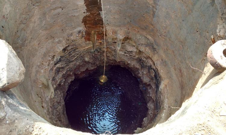
In the Bundelkhand craton region, groundwater is the primary source of drinking water. Due to low rainfall, agriculture mainly depends on the goundwater supply, which comes through bore wells. Most of the time, the region faces a water crisis during the summer season as the wells and tube wells go dry.
Conventional approaches used to determine groundwater potential such as geological, geophysical, drilling and field surveys for the past few decades are time-consuming, less accurate and costly. To overcome this, geographic information systems (GIS) and remote sensing (RS) based techniques have been used to delineate the groundwater potential.
Remote sensing techniques are always helpful in determining a suitable place for other exploration methods such as the electrical resistivity method and drilling method. It minimizes the time, risk and expenditure in groundwater management. Numerous studies have been performed worldwide in which remote sensing data is used to delineate the groundwater potential zones, the advancement in the remote sensing technique reduces the cost, time and manpower and also provides the results with high accuracy.
Many authors have found the groundwater potentiality by integrating different parameters that influence the groundwater by weighted overlay tool in ArcGIS software after assigning the suitable weights to these factors based on the expert opinion and existing literature available.
The present research has proposed GIS and RS and frequency ratio as a multi-criteria decision analysis (MCDA) tool-based approach to delineate the groundwater prospective zones in the Bundelkhand region in central India. The research paper published in the ‘The Egyptian Journal of Remote Sensing and Space Science’, Volume 25, Issue 2, 2022 aims to find the groundwater prospective areas by using GIS and RS based frequency ratio technique.
The data sets that affect groundwater such as geomorphology, lithology, slope, soil, rainfall, drainage density, lineament density and land use/ land cover were taken under consideration to find the groundwater prospective areas in the Bundelkhand region. Thematic maps of all the above-mentioned factors have been prepared from the remotely sensed data, data taken from the different organizations and departments.
Multi-criteria decision analysis helps to make decisions according to their preference. The weights of each attribute class of each thematic layer are assigned according to the frequency ratio technique. A total, 799 numbers of spring locations and discharge rate data of 108 numbers of well locations have been taken under consideration to obtain the frequency ratio of each attribute class of every parameter used and test the obtained result, respectively.
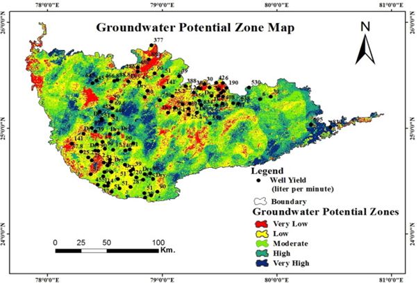
Finally, all layers were combined by raster calculator command in ArcGIS software to develop the map of groundwater prospective zones in the Bundelkhand region. The produced groundwater prospective areas were classified into five different zones such as very high, high, moderate, low and very low prospective zones and verified by actual well yield data.
The Bundelkhand region is characterized by different types of geological formations such as the Vindhyan supergroup, fine-grained granite, migmatite, granite, gneiss, and meta-sediments. The Bundelkhand craton region is bounded by the plane of Yamuna and Ganga River in the north, Narmada, and tributaries of Ken and Betwa in the south direction. This area is geologically a hard rock area with limited groundwater resources.
The groundwater in the Bundelkhand craton region mainly occurs in hard rock terrain areas under unconfined aquifers due to secondary permeability and porosity. The confined and unconfined aquifer conditions were found in the alluvial condition.
The region is characterized by the secondary permeability. The transmissivity of this region varies from 20 to 250 m2/day. According to the data obtained from the Central Groundwater Board, Lucknow, India, the yield of the wells in this region ranges from 0 (dry well) liter per minute to 880 L per minute.
Conclusion
In this research, eight different hydrological and hydrogeological factors that influence the occurrence of groundwater in this region are taken under consideration. The frequency ratio of each attribute class of every factor is calculated.
Finally, these factors were integrated by the raster calculator command in ArcGIS software to obtain the study area's groundwater potential zones. The obtained results were classified into five different classes, namely very low (9.72%), low (25.97%), moderate (31.72%), high (23.36%) and very high (9.22%) potential zone classes.
The results are validated from the 108 well yield/discharge data of the study area. Remote sensing and GIS applications are effective when it is applied at the beginning of groundwater investigations. This method reduces the area under consideration for research using alternative techniques, i.e., geophysical exploration methods, borehole drilling, etc. The proper implementation of remote sensing data can increase drilling success rates by a factor of ten and lower exploration expenditures.
The main advantage of using GIS and remote sensing-based frequency ratio method in the Bundelkhand region to delineate the groundwater potential zone is that, this technique provides a very efficient and systematic approach to demarcate the groundwater potential zones in this region, as well as this technique saves cost, time, manpower and provide an accurate result. The disadvantage of using this technique is that it requires skilled persons.
The present approach can be applied in different parts of the world to demarcate the groundwater potentiality where hard rock lithology has been seen. It has been reported that in built-up and urban regions, significant volumes of surface water are not infiltrating from the earth's surface into the aquifer for future storage.
The findings of this research may also be helpful in raising public awareness among legislators and researchers that rainwater collection, vegetation, and other appropriate engineering techniques should be encouraged in urban areas for proper recharging and storage of groundwater for future use.
The full paper can be accessed here
/articles/groundwater-prospective-zones-bundelkhand