Atpadi, a taluka in Sangli district of southern Maharashtra and situated in the rain-shadow of the Western Ghats, was often called as ‘the land of dushkal (droughts)’ and experienced one of its worst droughts in 2012, followed by those again in 2016 and 2019.
The story of how the region has turned its situation around since then is extraordinary and has its roots in the farmers’ movement – the Samanyayi Pani Vatap Sangharsh Chalwal in the region that started in the 1980s. The Maharashtra government had agreed to sanction funds for the Tembhu Lift Irrigation Scheme (TLIS), which would lift water from the Krishna Basin in five stages and provide water to drought affected regions of Sangli, Satara and Solapur districts with Atpadi being one of them.
The movement negotiated with the government to redistribute water in an equitable manner in Atpadi, ensuring that every home, regardless of land ownership, received at least 5000 m3 of water annually.
Now, water from the TLIS, along with local water in the form of both groundwater and surface water will need to be managed in an integrated and participatory manner by cluster Water Users Associations (WUAs) to ensure sustainable and fair allocation to all households including the landless.
Ensuring water for all
Can digital technology aid in helping WUAs to take better decisions and manage, govern and distribute water equitably, transparently and sustainably in the region?
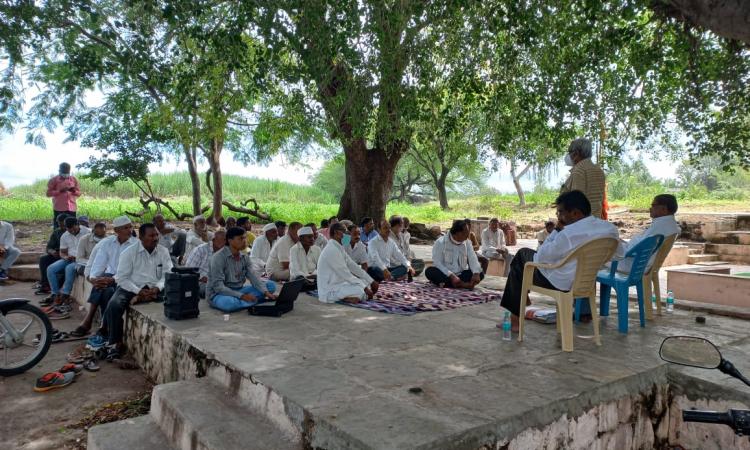
A pilot action research project undertaken by Society for Promoting Participatory Ecosystem Management (SOPPECOM) and TMG Research in the region explores the extent to which digital tools can enable farmers to improve integrated water management and governance by co-developing and co-piloting a digital application jointly with the WUAs.
What have been the experiences of other organisations who have piloted the use of digital technologies in water and natural resource management? SOPPECOM and TMG Research invited other actors in the water sector to a 1.5 day expert consultation, to share and discuss learnings for developing a collective understanding of digital tools in locally led water governance.
Making the invisible, visible
One of the interesting examples is that of The Water Stewardship initiative by Watershed Organisation Trust (WOTR), an NGO in Pune, which has focused on the use of technologies such as Community-Driven Visual Integrator (CoDriVE-VI or CDVI) to generate an operational 3D map of the local aquifers. This is to help communities in drought prone areas of Maharashtra visualise aquifers in their village, mobilise them to consider water as a common pool resource and manage the demand for water through crop water budgeting.
It has also developed “FarmPrecise”- an android-based mobile application that provides crop-specific weather-based information on up-to-date farming techniques, fertiliser and nutrient management, integrated pest, and disease management, irrigation water management, and market prices of different crops in nearby markets to help village communities take decisions on the selection of crops based on the weather patterns
Democratising data for sustainable management of natural resources
Foundation for Ecological Security (FES) on the other hand has focused on democratising access to socioeconomic and ecological information through spatial and temporal representation for sustainable management of natural resources and supporting local livelihoods for local level decisonmaking..
The India Observatory is a collaborative technology initiative by FES that presents detailed information on India’s social, ecological, and economic parameters related to natural resources on a single spatial and temporal platform and brings together data on over 1600+ parameters, ranging from village to national level presented in the form of maps, graphs, tables and infographics.
It also has a set of unique platforms and tools, namely, the Indian Biodiversity Information System (IBIS); the Composite Landscape Assessment and Restoration Tool (CLART), a geographic information system (GIS) tool developed to plan soil and water conservation measures by making location and context-specific data available; the Crop water budgeting tool, a geographic information system (GIS) tool developed to plan soil and water conservation measures by making location and context-specific data available; The Integrated Forest Management Tool (IFMT), the GIS Enabled Entitlement Tracking Tool (GEET) and the The Groundwater monitoring tool (Napo Jal Bachao Kal)
Mapping surface and groundwater resources, to aid decision making
Arid Communities and Technologies (ACT) works in the Kutch region where conserving water through recharging aquifers becomes crucial.
For this, information presented in the form of water resource, aquifer and watershed maps is made available by using data collected by people on the ground level related to surface and groundwater sources, aquifer-wide groundwater level and quality, local weather data, and water and soil quality and moisture data. The maps are used to make informed farm-level decisions to become water secure.
The technology used for monitoring data is gradually or stagewise introduced and includes data collected and stored in digital form using equipment and manually collected data. Static data such as farm geometry, location, soil type, hydrogeology, geomorphology, and water resources is combined with variable data that is regularly monitored by people at the ground level and water security plans are made.
ACT plans to develop comprehensive mobile applications to monitor data, train Bhujal Jankars to use this data, and develop laboratories for the maintenance of technical equipments.
Water passbook, to measure water balance
Gram Vikas, Odisha uses mWATER, an open-source tool used to estimate groundwater availability in a given area and can be compared to a Bank Passbook, which makes it easier for the community to understand the concept and use it to plan for water use and allocation.
Information on water levels is collected using a tool called Transect walk and recharge and discharge areas are demarcated and aquifers identified. After aquifer mapping, aquifer area and aquifer thickness can be estimated using GIS platforms and the storativity of the aquifer is calculated. which gets fed into the water passbook tool to estimate groundwater availability on any given day.
Jaltol for rural water security
Centre for Social and Environmental Innovation (CSEI) has developed Jaltol, a free and open source digital tool for water budget estimation. Since most agencies working in water sector are in need of water budget assessment and estimation of water balance and as most of them are small and do not have the inhouse capacity , the tool is an attempt to fill that gap where the CSOs with minimum inputs can get water budget estimation of their watersheds.
Understanding aquifers, through digital tools
Advanced Centre for Groundwater Resources and Development (ACWADAM) is using the mWaterapp for assessing the ground water potential in various villages of Atpadi Taluka in Sangli District and working along with SOPPECOM and Peoples movement for equitable water distribution and Irrigation Department, Govt of Maharashtra in Atpadi to aid in equitable distribution of irrigation water through integration of various sources.
Watershed development, using digital data
Bharat Rural Livelihoods Foundation (BRLF) is implementing Jivi Daah Hasa means Life (JDH) , a watershed project with the Mahatma Gandhi National Rural Employment Guarantee Act (MGNREGA) Cell, Rural Development Department, Government of Jharkhand in collaboration with civil society organisations to build planning capacities in MGNREGA to support livelihoods. The project aims at enhancing the incomes of marginal farmers while securing livelihoods and climate resilience through regenerating agroecology.
BRLF has been using the Open Data Kit (ODK) tool to prepare village DPRs for watershed treatment that collects data using android-based mobile devices which is submitted to an online server and A report is generated in the JDH web portal through ODK data BRLF plans to integrate this data with the MGNREGA in the future.
Technologies can empower
The above examples reveal that digital technologies can have varied applications and can be very useful in empowering people at the ground level with information that they can use to take decisions and manage their water resources sustainably. However,
Training and capacity building for making information understandable and usable is needed
Capacity building and facilitation is the key to encourage use
Handholding is essential to encourage communities to use technologies. Making monitoring systems farmer-led is very challenging, if not unrealistic. It requires tremendous support and facilitation by the project staff.
A lot of background work and capacity building is needed to make farmers/ communities feel comfortable to use digital tools for gathering, entering, collating, analysing and drawing inferences from the data.
Making information simple and easy to understand is important
Digital is not only about collecting and collating information. It is also about how this information is converted to meaningful data that is presentable and understandable at the community level.
Translation and adaptation of the information collected to convert it into meaningful data is a complex process and needs support and training.
Larger and contextual realities need to be factored in
Adapting the tools to suit specific contexts is crucial
While a number of tools are available, adapting the tools to make them suitable for local contexts is important. The correct selection of tools is also important taking into consideration the scale at which data is needed.
Use of technology might not automatically lead to decision-making and produce results on the ground
Mere access to information does not guarantee that this information will be used by people at the ground level to produce the desired results.
Making the effort sustainable beyond the completion of the project can be challenging and depends on the understanding and motivation of the community to bring about the desired change.
What happens after the projects are completed? To what extent does the farmer own the technology, what is the value of the technology for the farmer is an aspect that needs to be explored. How to incentivise farmers to keep monitoring and reporting data is a challenge that also needs to be addressed in the future.
While technologies have made the invisible, visible and helped to create awareness among people, has this awareness translated into changes in water use practices among people, has it led the community to formulate rules to use water sustainably and improve water governance? Do external factors such as market dynamics affect water use practices? Do digital tools bring transparency and how do local institutions cope with it are larger questions that need to be addressed in the future.
Gaps between micro and macro level data sets can make drawing inferences difficult
There is a huge gap between data sets that are available at the governmental level and that are collected at the ground level by people. Bridging this gap between micro and macro level data sets in terms of granularity and aiding the integration of data is important.
Hierarchies among communities can impact technology outreach
Access to digital technologies may not be uniform among communities
The sociocultural contexts and village-level hierarchies often determine who has access to information and can participate in decision-making.
There is data and information asymmetry in our communities. For example, women, poor, marginalised, and tribal populations continue to have poor access to resources and technologies. Including them in the mainstream will require efforts that expand beyond the adaptation of technologies to bring about social changes at the ground level.
Who needs, controls and owns the data and technology can affect outcomes
Technologies do not function in a vacuum and their uses can be influenced determined/controlled by the sociocultural and political contexts where they are used.
Thus power relations at the village level can influence who has access to data and can influence decision-making and equitable distribution of resources. How far technology can lead to democratic decision-making and equitable distribution of resources remains to be seen.
Technology can act as a double edged sword
While technology can play an important role in empowering communities with information and aiding them in taking decisions on the ground level, it can also act as a double-edged sword.
One needs to be wary of using technology as a solution to all evils. Questions such as who needs and controls technology, who uses it and what is it used for need to be placed at the centre of all discourses on the use of technology for the last mile.
/articles/digital-technologies-locally-led-water-governance