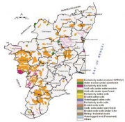
This book by NAAS and ICAR builds-on and integrates work done by different institutes of the ICAR and the Department of Space in the area of degraded and wastelands in India. NRSA had already published the state level and country level information earlier. In addition, the nature and causes of the land degradation, and the degree and extent of damaged lands needed to be determined, so that appropriate management strategies could be designed and implemented in a defined time-frame to bring these lands to ‘productive health’.
This task undertook harmonization of disparate databases on degraded and wastelands into most practical classes that respond to amendments. To be useful to the planners, administrators, decision-makers and fund managers of the land-based agricultural development programmes for varied purposes, district-level data in agro-ecological regional framework has been used to develop an innovative database analytic system. The chapter-wise contents of the report are outlined here –
- Chapter 1 on introduction, narrates the problems associated with the loss of productivity and soil quality. Centrality of land resources in relation to climate change, environmental concerns and loss of biodiversity are also discussed both in the national and global context.

- Chapter 2 on historical background reviews efforts made over the last half a century by the Ministry of Agriculture, ICAR, NWDB and NRSC to classify and map degraded soils and wastelands.
- Chapter 3 on geographical scenario of India defines location, diversity of climates, physiography of the country and their impacts on the development of varied soils, landforms and land use.
- Chapter 4 on generation of input datasets describes data sources for mapping land degradation by incorporating datasets on water erosion, wind erosion, soil acidity and soil salinity generated through collaborative efforts of the ICAR Institutes.
- Chapter 5 on methodology describes harmonization process developed in the GIS core and followed for obtaining realistic estimates of the degraded and wastelands.
- Chapter 6 on spatial distribution of degraded and wastelands contains resultant map of the harmonization exercise.
- Chapter 7 describes detailed distribution of area of the various categories of degraded and wastelands in 20regions (AERs). The AER-based data can be used to simulate abiotic stressed land resources availability, use and production potentials.
- Chapter 8 gives extent and distribution of degraded and wastelands in different states of India.
- Chapter 9 discusses severity ranking of different states for different types of degraded lands.
- Chapter 10 describes scientific and technical relevance of this study.
- Chapter 11 enlists operational use of maps of datasets on degraded and wastelands by various ministries of the Government of India, the NGOs, and by the public institutions at large.
Download the report here
/articles/degraded-and-wastelands-india-status-and-spatial-distribution