Term Path Alias
/sub-categories/people-and-organisations
/sub-categories/people-and-organisations
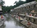
Bagmati river in Kathmandu: From holy river to unthinkable flowing filth
")
Ajaya Dixit initiated his presentation with a general account of how rivers shape the landscape and how riverine ecosystems have nurtured society and kept civilisations vibrant, cultured and creative. Dixit went on to discuss the basin characteristics of the Bagmati, a tributary of the Kosi that rises in the Shivapuri hills, north of the Kathmandu valley. Around fifteen percent of the basin area (3700 sqkm) lies in Nepal, while the remaining is in India. The average annual rainfall in the basin is 1400 mm and is more than 2000 mm in the hills. Bagmati is a seasonal river with rainfall and springs as its main source. Its mean flow is 15.6 cubic metre/second and low flow is 0.15 cubic metre/second in April.
Kathmandu lies in the Upper Bagmati basin and studies suggest that an ancient lake called the Paleo-Kathmandu lay within the Kathmandu valley as a lacustrine formation. Early settlers lived in lower slopes and used springs and river in the upper reaches. When they moved to the valley floor, they built dongia dharas, which are stone water spouts fed by the unconfined aquifers and delivered water through surface channels. Even today, dongia dharas dated back to 1500 years exist. The state built canals (raj kulo) tapped the upper stretches of the rivers close to the mountains. Rivers and irrigation helped recharge aquifers and ponds.
However, rising urbanisation has damaged these ancient artifacts. Over the last sixty years Kathmandu has expanded massively and its population has increased from 0.41 million in 1951 to 2.6 million in 2011. The city has a huge transient population aside from this, reducing it to a concrete nightmare. Seismologists suggest that Kathmandu is a rubble city in the making. Though the Bagmati river flow has not changed significantly in the last seventy years, the character of the river has been transformed significantly during the period 1970 to 1990. The river has been canalised while the dumping of the city’s garbage into it continues. Dixit identified a plethora of problems faced by the river such as upstream water diversion for drinking water needs, disposal of untreated liquid waste, disposal of solid waste, river jacketing for roads and commercial activities, sand mining and physical encroachment.
The state of the river is an outcome of the current approach to waste management particularly liquid waste management. Three types of waste water namely yellow water flux, grey water and yellow black flux are being generated and flowing water is being used as a vehicle to dispose these. The idea of a water based disposal system e.g. flush toilet embedded in Victorian engineering has led to a technological lock-in with the result that the notion of a natural hydrological cycle has undergone a fundamental transformation.
All the same, the bulk of the load in the river is biological though there are some factories releasing effluents. In the last 20 years some of them have been closed or relocated and the river now stands a chance of being salvaged.
Content courtesy: National Alliance for People's Movements
On the 26 December, 2011, at 2:15 am, Assam Police in collusion with other security forces swooped down on the protesters at Ranganadi who have been blockading the Highway since December 16 and thwarting state’s attempt to carry turbines and dam materials to project site of Lower Subansiri Dam. Nearly 200 people have been arrested and earlier also security forces have been harassing the protestors. In past too, Krishak Mukti Sangram Samiti fighting against the big dams on Brahmaputra have faced government’s ire and often been attacked and jailed. NAPM stands in solidarity with KMSS and other students groups of the region who have been consistently opposed to the big dams in highly sensitive seismic zone. We condemn the sustained action and harassment of KMSS and their activists and targeting of Akhil Gogoi for constantly opposing the destructive development policies and corruption of the government machinery.
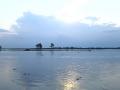
Rivers in North-East India
Article and Image courtesy: PC Quest
Auhtor: Shumpy Saini
An online portal that provides the right aid and resources to the right people at the right time when disaster strikes.
 With a belief that those who serve people in need shouldn't have to sacrifice on the tools they use, Aidmatrix Foundation came up with CDRN. It's an online portal that helps bring people together with the use of applications for supply-chain management, volunteer management and fund raising. People can enter their needs, donations, products or supplies into the CDRN system, which is in turn accessed by a nationwide network of relief agencies, corporates, state Governments, federations, and PSUs. It allows donors to provide discounted pricing offers as well as donations directly to various relief agencies by viewing needs posted on the system.
Author: Namitha Dipak, Lokhit Pashu-Palak Sansthan
 Shree Padre, farmer, water journalist, and rainwater harvesting “evangelist” based in Kerala, India
Date of Incident: 6 June 2011 at around 7 A.M
Place of Incident: Yaipha Leikai, Lamphelpat, Under Lamshang Assembly Constituency, Imphal West District, Manipur, India
Victims/Community Affected: 15 Households, 81 persons belonging to the Meitei People of Manipur
The displaced victims are mostly women, children and elderly people
Event Description:
On 6 June 2011, at least fifteen (15) houses of Yaipha Leikai village, Lamphelpat Wetland near Employment Exchange, Imphal West District, Manipur in India’s North East had been destroyed by Manipur Police from the Lamphel Police Station under the orders of the Government of Manipur on 6 June 2011 as a means to evict the villagers to make way for the Government plan for building the National Institute of Technology (NIT) complex and a water body at Lamphelpat wetlands.
Prior to the eviction, an order issued by the Sub Divisional Officer, Lamphel, Imphal West on 3 June 2011 was served to the villagers of Yaipha Leikai only on Sunday, the 5 June, 2011 around 10 a.m in the morning asking them to dismantle their houses the same day before 5 in the evening. The villagers were completely taken by surprise as most of the senior household occupants were off to work in Lamphelpat Wetlands for fishing and many went out to earn as daily labourers. The eviction drive was carried out on 6 June 2011, the next day from around 7 a.m in the morning. The eviction process was overseen by State Works minister K Ranjit, PDA chairman Kh Loken among other officials of different departments and police officials of Lamphel Police Station, Imphal West District. The eviction was carried out by using earthmovers and other heavy machineries despite the angst of the residents, who have resided in the area for more than four decade.
Residents of L&T South City and Brigade Millenium in JP Nagar, Bangalore formed a citizen initiative to save the neighbouring Puttenahalli Lake from becoming a dumping ground for construction debris and waste. A team from India Water Portal visited the lake in June 2011 to see the progress and challenges faced by such citizen initiatives.
In May 2008, PRADAN initiated the SRI method of paddy cultivation in selected areas of Chhattisgarh through its partner organisations with financial support from Sir Dorabji Tata Trust (SDTT). It supported 11 NGOs who together could reach 4600 framers in 9 districts of Chhattisgarh in last Kharif.