Mirzapur District

Term Path Alias

/regions/mirzapur-district

Covid-19: The road back home
A rapid study highlights the plight of homebound migrant workers of Mirzapur and Prayagraj districts of Uttar Pradesh after Lockdown 1.0 Posted on 29 Apr, 2020 09:30 AM

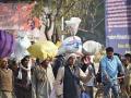
Raj Kumar, 32, a daily wager employed at a factory in Delhi had barely a thousand rupees in his wallet when he readied to rush back to his village in Halia block of Mirzapur, Uttar Pradesh. On a normal April afternoon, he took the highway that leads to his district hearing about the 21-day lockdown.

Millions of migrants rushed to return to their villages amid the lockdown (Image: Pixabay/balouriarajesh. Pixabay licence)
Ecologists challenge Bharti's remark on Ken-Betwa
Policy matters this week Posted on 05 Jan, 2017 11:20 AM

No final approval for Ken-Betwa river link as claimed by Centre

The Ken-Betwa river link shown on a map. (Source: Shannon via Wikipedia)
Abolish manual scavenging: SC
Policy matters this month: SC directs all states to abolish manual scavenging; MoEF reduces ESA in its new draft notification on Western Ghats; Maharashtra all set to clean its rivers. Posted on 31 Mar, 2014 11:14 PM

Abolish manual scavenging: SC

A manual scavenger in Chennai (Namathu Blogspot)
Environment Minister Moily takes controversial decisions
Policy Matters this week: Moily takes controversial decisions on the Western Ghats, UP declares eco-sensitive zone around sanctuaries and the UN appreciates Odisha's disaster management efforts. Posted on 29 Dec, 2013 06:54 PM

New Environment Minister brings in new polices

Environment Minister Moily (Source: Livenewz)
An integrated approach of remote sensing, geophysics and GIS to evaluation of groundwater potentiality of Ojhala subwatershed, Mirzapur district, U.P.
The study shows that integrated remote sensing and GIS has proved to be an efficient tool in groundwater studies and can give more realistic picture of groundwater potentiality of an area Posted on 19 May, 2009 11:51 AM

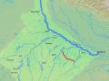
This paper uses an integrated approach of Remote Sensing, Geophysics and GIS to evaluate groundwater potentiality of Ojhala subwatershed in Mirzapur district of Uttar Pradesh.

Groundwater potential modelling in Chandraprabha subwatershed, Uttar Pradesh- a case study in GIS development
The study aims to find suitable sites for groundwater exploration in Chandraprabha subwatershed in Uttar Pradesh using remote sensing, geoelectrical and GIS approach Posted on 19 May, 2009 11:36 AM

This study on the GIS Development site attempts to select suitable locations for groundwater exploration in hard rock areas using an integrated approach of remote sensing, geoelect

×