Term Path Alias
/regions/bankura-district
/regions/bankura-district
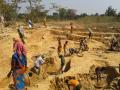
Amulya Soren couldn’t get stable yields in the kharif (monsoon) paddy in his farm. A member of the Santhal tribe, he was the beneficiary of a surplus land redistribution programme in Hirbandh block of Bankura, West Bengal. The undulating terrain in which his farm lies receives sufficient rainfall of about 1000 mm a year, yet sufficient irrigation was an issue.
Centre identifies 115 wetlands for conservation and management

The article deals with AVSWAT- A spatial decision support system for land and water management and its application for watershed management in Bankura district of West Bengal. Decision Support Systems (DSS) are defined as computer-based information systems designed to support decision makers interactively in thinking and making decisions about relatively unstructured problems. Spatial Decision Support Systems (SDSS), which are the integration of DSS and GIS was initiated by Densham and Goodchild ( 1988) are emerging as efficient tools for managing natural resources like land and water.