Term Path Alias
/regions/bagmati
/regions/bagmati
Introduction: The Ganges
The first discussion was on June 4 2011, in which Rama Rauta and K C Sivaramakrishnan shared their experiences of working with the government and people’s organisations to save the Ganga.
The twin sisters: Bihar is a land of fertile farms bearing sugarcane, wheat, rice, gram and pulses. Interspersed between the fields are venerable mango groves. Of Bihar's children, perhaps none is as universally loved as Sita. The village that she was born in -Sitamarhi- welcomed another daughter along with Sita.

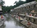
Bagmati river in Kathmandu: From holy river to unthinkable flowing filth
")
Ajaya Dixit initiated his presentation with a general account of how rivers shape the landscape and how riverine ecosystems have nurtured society and kept civilisations vibrant, cultured and creative. Dixit went on to discuss the basin characteristics of the Bagmati, a tributary of the Kosi that rises in the Shivapuri hills, north of the Kathmandu valley. Around fifteen percent of the basin area (3700 sqkm) lies in Nepal, while the remaining is in India. The average annual rainfall in the basin is 1400 mm and is more than 2000 mm in the hills. Bagmati is a seasonal river with rainfall and springs as its main source. Its mean flow is 15.6 cubic metre/second and low flow is 0.15 cubic metre/second in April.
Kathmandu lies in the Upper Bagmati basin and studies suggest that an ancient lake called the Paleo-Kathmandu lay within the Kathmandu valley as a lacustrine formation. Early settlers lived in lower slopes and used springs and river in the upper reaches. When they moved to the valley floor, they built dongia dharas, which are stone water spouts fed by the unconfined aquifers and delivered water through surface channels. Even today, dongia dharas dated back to 1500 years exist. The state built canals (raj kulo) tapped the upper stretches of the rivers close to the mountains. Rivers and irrigation helped recharge aquifers and ponds.
However, rising urbanisation has damaged these ancient artifacts. Over the last sixty years Kathmandu has expanded massively and its population has increased from 0.41 million in 1951 to 2.6 million in 2011. The city has a huge transient population aside from this, reducing it to a concrete nightmare. Seismologists suggest that Kathmandu is a rubble city in the making. Though the Bagmati river flow has not changed significantly in the last seventy years, the character of the river has been transformed significantly during the period 1970 to 1990. The river has been canalised while the dumping of the city’s garbage into it continues. Dixit identified a plethora of problems faced by the river such as upstream water diversion for drinking water needs, disposal of untreated liquid waste, disposal of solid waste, river jacketing for roads and commercial activities, sand mining and physical encroachment.
The state of the river is an outcome of the current approach to waste management particularly liquid waste management. Three types of waste water namely yellow water flux, grey water and yellow black flux are being generated and flowing water is being used as a vehicle to dispose these. The idea of a water based disposal system e.g. flush toilet embedded in Victorian engineering has led to a technological lock-in with the result that the notion of a natural hydrological cycle has undergone a fundamental transformation.
All the same, the bulk of the load in the river is biological though there are some factories releasing effluents. In the last 20 years some of them have been closed or relocated and the river now stands a chance of being salvaged.
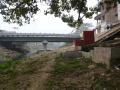
 The Bagmati Embankment separating riverside on the left and countryside of the right near Ibrahimpur – Electric poles suggest the height of the embankment
One often hears about the civilizations buried under earth and attributes various reasons for such disappearance of life from a particular place. Excavations reveal the way of life the people might have had before they chose to leave their villages and towns and allowed the nature to take its own course. These accounts are available in books and we all believe the process told to us by historians and archaeologists. These are all conjectures that are revealed by scientific investigations but how many of us have seen, not read, how the civilizations get buried under the debris created by nature? There are places in Bihar where one can see the process of disappearance of civilization and the villages getting buried under the sediments brought by rivers.
The following map from South Asia Network on Dams Rivers & People gives a schematic sketch of the Bagmati Breach site near Tajpur in Bihar’s Sitamarhi district.
The google map at this URL shows Runi Sayedpur and Sitamarhi, along national highway 77: http://tinyurl.com/lxwfmj
1) A presentation from the Central Water Commission of the Government of India studying the flood problem on the Bagmati and making some recommendations:
flood-management-in-bagmati-basin
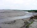
Photograph of flooding due to breach in Bagmati's embankment, taken by NGO: Ghoghardiha Prakhand Swarajya Vikas Sangh, Madhubani"
"If it had not breached at Kusaha, it would have anyway breached at this point," points a villager towards the probable location on the eastern bank in village Rajabaas near Prakashpur in Sunsari district of Nepal, located 14 km upstream of Kusaha where the Eastern Afflux embankment of the Kosi had breached on the August 18, 2008.