NASA
Summer monsoon transforms northeastern Bangladesh - Updates from NASA Earth Observatory in 2011
Posted on 15 Jul, 2011 02:57 PMArticle and Image courtesy: NASA
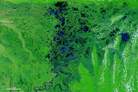
 Bangladesh typically experiences a mild winter from October to March; a hot, muggy summer from March to June; and a warm, rainy monsoon from June to October. By early July 2011, rains had already transformed northeastern Bangladesh.
Flood extent in Pakistan - Updates from NASA Earth Observatory
Posted on 26 Apr, 2011 11:41 AM
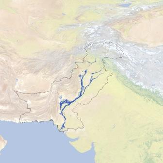
La Niña conditions increased atmospheric moisture and an unusual pattern in the jet stream trapped rainy weather over the country. According to the Pakistan Meteorological Department, nationwide rain totals were 70 percent above normal in July, and 102 percent above normal in August.

Lingering floods in Pakistan - Updates from Earth Observatory
Posted on 15 Apr, 2011 09:49 AM
A combination of factors, including La Niña and a strange jet stream pattern, caused devastating floods. The Indus River rapidly rose, and a dam failure in Sindh Province sent part of the river down an alternate channel. The resulting floodwater lake lingered for months, leaving crops, roads, airports, even entire communities underwater.
Heavy Rains in Sri Lanka - Update from Earth Observatory
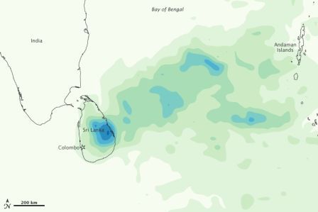
Posted on 20 Jan, 2011 01:48 PMSri Lanka’s government stated that the death toll from flooding had risen to 13, and officials were arranging food drops to hardest-hit areas in the east.

![]()
Greener climate prediction by NASA shows plants slow warming
Posted on 20 Dec, 2010 06:01 PMArticle and Image Courtesy: NASA
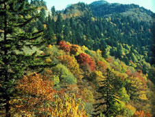
A new NASA computer modeling effort has found that additional growth of plants and trees in a world with doubled atmospheric carbon dioxide levels would create a new negative feedback – a cooling effect – in the Earth's climate system that could work to reduce future global warming.
 A new NASA modeling effort found that in a doubled-carbon dioxide world plant growth could lessen global warming by about 0.3 degrees C globally. The same model found that the world would warm by 1.94 degrees C without this cooling feedback factored in. Image: Great Smoky Mountains National Park; Credit: National Park Service
Global warming mapped: Updates from Earth Observatory
Posted on 20 Dec, 2010 05:44 PMArticle Courtesy: Earth Observatory
Image Courtesy: NASA
The world is getting warmer. Whether the cause is human activity or natural variability, thermometer readings all around the world have risen steadily since the beginning of the Industrial Revolution.
Unusually intense monsoon rains in many parts of Asia - Article from Earth Observatory
Posted on 13 Sep, 2010 11:20 PM

The first week of August 2010 brought extreme flooding and landslides to many parts of Asia. By August 11, floods in the Indus River basin had become Pakistan’s worst natural disaster to date, leaving more than 1,600 people dead and disrupting the lives of about 14 million people, reported Reuters. Across the border in northeast India, flash floods killed 185 with 400 still missing, reported BBC News. Floods in North Korea and northeast China buried farmland and destroyed homes, factories, railroads, and bridges. And in northwest China, rain triggered a massive landslide that left 702 dead with 1,042 missing, reported China’s state news agency, Xinhua. All of these disasters occurred as a result of unusually heavy monsoon rains, as depicted in the above image.
NASA Earth Observatory: Cyclone Bijli
Posted on 07 May, 2009 12:03 PMImage & Content Courtesy: NASA Earth Observatory
 A ragged-looking Tropical Storm Bijli draped the east coast of India in this image from the Moderate Resolution Imaging Spectroradiometer (MODIS) on NASA's Terra satellite on April 16, 2009. Bijli became a tropical storm in the northwest Bay of Bengal on April 15, and initially headed north, toward the west coast of India. By April 16, it had begun a northeastward turn, however, and the storm was being projected to make landfall in eastern Bangladesh on April 17, according to Unisys. Access higher resolution image here:Cyclone Bijli
Floods in Northeastern India - Images from NASA
Posted on 04 Nov, 2007 02:29 PM  Moderate Resolution Imaging Spectroradiometer (MODIS) on NASA's Aqua satellite captured images of flooded Brahmaputra River.
NASA satellite tracks changes in Earth's freshwater distribution
Posted on 04 Nov, 2007 02:19 PM (Image taken from the NASA page mentioned below) Several African basins, such as the Congo, Zambezi and Nile, show significant drying over the past five years. In the United States, the Mississippi and Colorado River basins show water storage increases during that time.