Amita Bhaduri
Citizens voice alarm over recent Supreme Court judgement on interlinking of rivers
Posted on 25 Apr, 2012 10:39 AMThe Supreme Court of India has in its judgment of 27 February 2012 on the interlinking of rivers project, given categorical directions to the Executive Government to implement the ‘project’ as a whole in a time bound manner and has also asked the Centre to appoint a Special Committee to work out the modalities and oversee the implementation of the project.
Living rivers, dying rivers: Rivers in the Western Ghats
Posted on 10 Feb, 2012 04:12 PMRiver stories from Maharashtra: Many morals to learn
Parineeta Dandekar’s presentation began with an account of some statistics related to Maharashtra, the third largest state in India. Regarding the state of water resources in Maharashtra, she noted that of the five river basin systems, 55 percent of the dependable yield is available in the four river basins (Krishna, Godavari, Tapi and Narmada) east of the Western Ghats. These four river basins comprise 92 percent of the cultivable land and more than 60 percent of the population in rural areas. 45 percent of the state's water resources are from west flowing rivers which are mainly monsoon specific rivers emanating from the Western Ghats and draining into the Arabian Sea.
With 1821 large dams and more in the offing, Maharashtra has the maximum dams in the country (35.7%). However, the proportion of gross irrigated area vis a vis the gross cropped area at 17.8 percent is much lower than the national average of 44.6 percent. The contradictions from the state, which is home to the highest number of dams, were discussed. In nearly 70 percent of the state’s villages (around 27,600 villages), water is either not available within 500 metres distance, or within 15 metres below ground level or when available is not potable (World Bank, Promoting Agricultural Growth in Maharashtra, Volume 1, 2003).
Dandekar discussed the World Bank funded Maharashtra Water Sector Improvement Project (MWSIP) initiated in 2005 whose main components were establishment, operationalisation and capacity building of Maharashtra Water Resources Regulatory Authority (MWRRA); establishment of river basin agencies in Maharashtra; and restructuring and capacity building of the Water Resources Department. The MWRRA Act (2005) has been amended, taking out the clause for equitable water distribution, and granting the Cabinet the rights to have the last say about water entitlements. This has led to a diversion of water for irrigation from the vulnerable, suicide-prone Vidarbha region to thermal power plants. According to Prayas, “entitlements of more than 1500 MCM have been changed from agriculture to industries and cities”.

Safe water dissemination workshop by PATH held on January 19-20, 2012 at New Delhi
Posted on 07 Feb, 2012 10:15 PMGuest post: Amita Bhaduri
Through the Safe Water Project, it is seeking complementary solutions to sustainability and scale-up by exploring the potential for commercial enterprises to produce, distribute, sell, and maintain Household Water Treatment and Storage (HWTS) consumer products to low-income populations. The workshop shared learnings and tools from PATH’s Safe Water Project and presented the experiences of other organizations that are leveraging market-based approaches to achieve a sustainable public health impact.

River basin planning for Ganga : Lessons from Murray-Darling Basin Authority
Posted on 02 Feb, 2012 09:15 PMThis interactive session with NGOs working on water and river issues was held in continuation of the “Living rivers, dying rivers” series at the request of AusAid. The meeting was chaired by Prof. Ramaswamy R. Iyer, Honorary Professor, Centre for Policy Research and an author of books and articles on water while the lead speaker Dr.
Living rivers, dying rivers: Bagmati river in Nepal
Posted on 05 Jan, 2012 06:07 PMBagmati river in Kathmandu: From holy river to unthinkable flowing filth

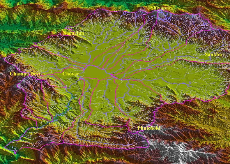
Ajaya Dixit initiated his presentation with a general account of how rivers shape the landscape and how riverine ecosystems have nurtured society and kept civilisations vibrant, cultured and creative. Dixit went on to discuss the basin characteristics of the Bagmati, a tributary of the Kosi that rises in the Shivapuri hills, north of the Kathmandu valley. Around fifteen percent of the basin area (3700 sqkm) lies in Nepal, while the remaining is in India. The average annual rainfall in the basin is 1400 mm and is more than 2000 mm in the hills. Bagmati is a seasonal river with rainfall and springs as its main source. Its mean flow is 15.6 cubic metre/second and low flow is 0.15 cubic metre/second in April.
Kathmandu lies in the Upper Bagmati basin and studies suggest that an ancient lake called the Paleo-Kathmandu lay within the Kathmandu valley as a lacustrine formation. Early settlers lived in lower slopes and used springs and river in the upper reaches. When they moved to the valley floor, they built dongia dharas, which are stone water spouts fed by the unconfined aquifers and delivered water through surface channels. Even today, dongia dharas dated back to 1500 years exist. The state built canals (raj kulo) tapped the upper stretches of the rivers close to the mountains. Rivers and irrigation helped recharge aquifers and ponds.
However, rising urbanisation has damaged these ancient artifacts. Over the last sixty years Kathmandu has expanded massively and its population has increased from 0.41 million in 1951 to 2.6 million in 2011. The city has a huge transient population aside from this, reducing it to a concrete nightmare. Seismologists suggest that Kathmandu is a rubble city in the making. Though the Bagmati river flow has not changed significantly in the last seventy years, the character of the river has been transformed significantly during the period 1970 to 1990. The river has been canalised while the dumping of the city’s garbage into it continues. Dixit identified a plethora of problems faced by the river such as upstream water diversion for drinking water needs, disposal of untreated liquid waste, disposal of solid waste, river jacketing for roads and commercial activities, sand mining and physical encroachment.
The state of the river is an outcome of the current approach to waste management particularly liquid waste management. Three types of waste water namely yellow water flux, grey water and yellow black flux are being generated and flowing water is being used as a vehicle to dispose these. The idea of a water based disposal system e.g. flush toilet embedded in Victorian engineering has led to a technological lock-in with the result that the notion of a natural hydrological cycle has undergone a fundamental transformation.
All the same, the bulk of the load in the river is biological though there are some factories releasing effluents. In the last 20 years some of them have been closed or relocated and the river now stands a chance of being salvaged.

Yamuna-Elbe - A public art and outreach project at the Yamuna riverscape in Delhi launched on 5 November, 2011
Posted on 18 Dec, 2011 02:02 PMGuest post by: Amita Bhaduri
The public art outreach project was organized by the Max Mueller Bhavan in association with the Government of Delhi and the Goethe-Institut (Hamburg, Germany) as a part of the “Year of Germany in India” programme opened on 5th of November, 2011. The art exhibition which continued till the 19th of November co-curated by artist Ravi Agarwal who is also a practicing environmentalist (Director, Toxics Link) along with German artist, Till Krauser attempted to create a pulsating synergy between the Yamuna and Elbe rivers.
 Gigi Scaria’s - The fountain of purification
Photo courtesy: Rocky Thongam
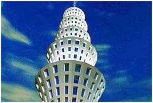
This is a 24 ft installation representing a four storey apartment complex that draws Yamuna water, purifies it at various levels and dispenses it from the top in the form of a fountain.
Traditional water bodies of Delhi
Posted on 18 Dec, 2011 01:56 PMSohail Hashmi, an author, film-maker, one of the founders of the Safdar Hashmi Memorial Trust (SAHMAT) and a true Dilliwala on 5 December 2011 at the India Habitat Center. The presentation woven around photographs of the city's step well
Living rivers, dying rivers: Rivers in North East India
Posted on 15 Nov, 2011 03:29 PMRivers in North-East India

Man-made floods in Orissa in September 2011- Key issues raised by Water Initiatives Orissa
Posted on 06 Oct, 2011 10:24 AMOrissa was hit by two spates of flood in September 2011, the first one being caused by heavy rains in the Mahanadi catchment and release of huge discharges from Hirakud dam. The second one was caused by heavy rains and flooding of Brahmani, Baitarani and Budhabalanga rivers. These floods point to the loopholes in river basin planning and management and calls for urgent attention of planners and policy makers.
Reap what you sow, eat what you grow A film by Suma Josson on urban community farms promoted by Urban Leaves in Mumbai
Posted on 24 Sep, 2011 06:21 PMReap what you sow, eat what you grow - A film by Suma Josson
It depicts how applying ecological principles and practices to maintain soil fertility, to manage crop health, and to keep soil and water in a good condition is especially relevant to the urban setting. The film focuses on the work being done in the urban farms, yet it can be seen as much more than that and, understood as a vision on healthy products, healthy production systems and as a way of life.