 The historic tsunami of 2004 in the northern Indian Ocean severely affected the eastern coastal areas of peninsular India and Andaman-Nicobar Islands. The Andaman-Nicobar Islands experienced intense damage to the coastline, at places reaching several hundred metres deep into the island.
Car Nicobar was one such area badly affected by the tsunami in a broad belt running along the shore, killing about 600 inhabitants. The island has an extensive span of sea on all sides and was the worst hit area in the Andaman-Nicobar Islands. The present work is the result of a comparison of observations made in the late sixties and after the 2004 tsunami.
The Island, being the type area of Neogene stratigraphic units and one of the earliest studied areas for detailed micropalaeontological work, occupies a distinct place in the geology of Andaman–Nicobar Islands. The stratotype sections of Sawai Bay Formation as well the Sawaian Stage are located at Car Nicobar. Geological work on Car Nicobar dates back to the Novara expedition.
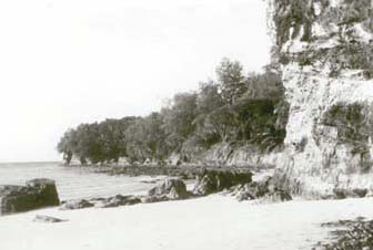
The tsunami resulted in significant ground deformation (uplift and subsidence) in the Andaman-Nicobar Islands, including Car Nicobar. The ensuing tsunami, which devastated the coastline of Car Nicobar, washed away huge boulders lying on the shore at Sawai Bay section in the northern part of the island. It also exposed the relationship, hitherto unknown, among the rock formations.
The rock boulders which were covering the exposures and obscuring the relationship among different strata were completely washed away due to the impact of the tsunami, revealing the relationship between the mudstone of the Sawai Bay Formation and the rock formation below it.
The paper seeks to amend the stratigraphy of Car Nicobar in the light of the recent discovery of relationship between the mudstone of the Sawai Bay Formation and the underlying rock unit.
The paper can be downloaded below –
/articles/impact-2004-tsunami-geology-car-nicobar-island-paper-current-science