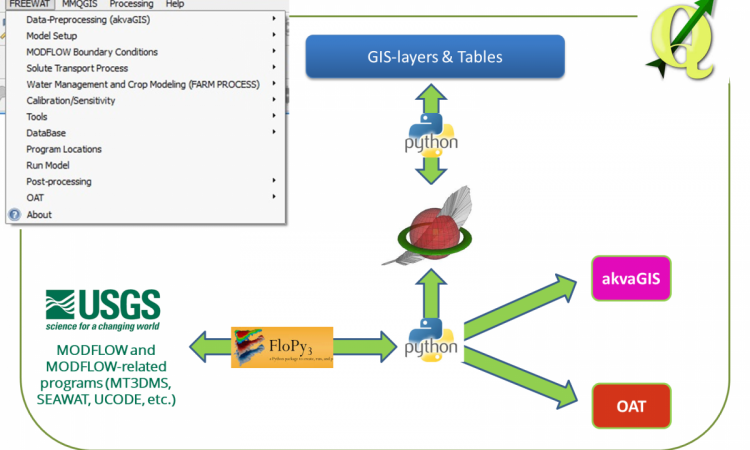
FREEWAT (FREE and open source software tools for WATer resource management) is a HORIZON 2020 project financed by the EU Commission under the call WATER INNOVATION: BOOSTING ITS VALUE FOR EUROPE. FREEWAT's main result is an open source and public domain GIS integrated modelling environment (the FREEWAT platform) for the simulation of water quantity and quality in surface water and groundwater with an integrated water management and planning module.
If you are interested in water management and in simulation tools please visit the Software and Training page of this web site. FREEWAT is conceived as a composite plugin for the well-known GIS open source desktop software QGIS (http://qgis.org).
As composite plugin, FREEWAT is designed as a modular ensemble of different tools: some of them can be used independently, while some modules require the preliminary execution of other tools.
In this framework, the following tool classifications can be defined:
- Tools for the analysis, interpretation and visualization of hydrogeological and hydrochemical data and quality issues, also focusing on advanced time series analysis, embedded in akvaGIS module.
- Simulation of models related to the hydrological cycle and water resources management: flow models, transport models, crop growth models, management and optimization models (also related to irrigation management and rural issues).
- Tools to perform model calibration, sensitivity analysis and uncertainty quantifications.
- Additional tools for general GIS operations to prepare input data, and post-processing functionalities (module OAT – Observation and Analysis Tool).
Read more details about the upcoming remote training programme (5th March - 3rd June) here http://www.freewat.eu/news/new-round-of%C2%A0freewat-remote-training.
The Freewat software can be found here http://www.freewat.eu/software-0
This article was contributed to the India Water Portal by Craig D'Souza from Datameet, Pune.
/articles/freewat-free-and-open-source-software-tools-water-resource-management