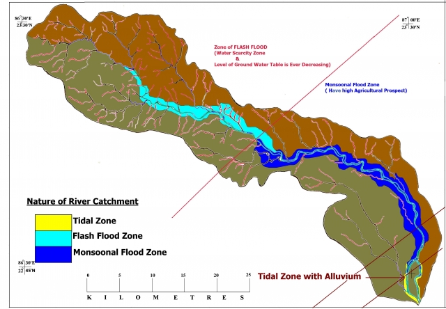
 In India, at national level when all the planners are saying about the water grid, river linking project, in this particular situation it is very essential to assess the flood characteristic of Dwarekeshwar river of West Bengal.
The most remarkable identity of Dwarekeswar River (200.5km long) is that, it consists of transitional characteristics of both flash floods it its upper catchments, monsoonal flood in the middle and tidal effect in its lower confluence simultaneously. Dwarekeswar River is a major river in the western part of West Bengal. It originates from extended part of Chotanagpur plateau (geographical extension 86°31´E to 87°02´E) in Purulia District and ended in the alluvial tract of West Mednapur (22°42´30´´N to 23°31´N) of West Bengal.(Fig. 1).The monthly mean temperature at summer is 32.55°C and in winter is 18.98°C. The average rainfall is 117.76 mm per year. The diurnal range of temperature varies from 4 °C to 9° C. The upper catchments are suffering from acute scarcity of drinking water during the months of April to May. Upper part is overcrowded by the dug well (8 to 11 well in each 200m linear distance), middle and lower are overcrowded by the deep tube well irrigation (up to the depth of 50 m).
Flash Flood and Upper Catchments of Drarekeshwar river: The incident of flash flood of the plateau river is not new one but this type thrice combination is unique. The incident of flash occur just in the beginning (with in the 3 to 6 days of monsoon) of monsoon (month of June). Here flash flood is not devastating one. But it creates problem of domestic animal and causes bank erosion near Joypur Block of Bankura District. This incident confines within its upper catchments up to Joypur Block of Bankura District. Monsoonal Flood and Middle Catchments of Drarekeshwar river: The incident of monsoonal flood is very common in the mid of monsoon (during the months of August) particularly in Arambagh and Khanakul Blocks of Hooghli district.
The entire flood incident occurs here in the day of late August to September. In those day, due to tidal effect in the lower catchments (which is 150 km away from the Bay of Bengal and it meets the river Bhagirathi) the huge amount of rainwater in river basin gets a backward onrush. Simultaneously its upper catchments consist of 12° to 21° slopes where as the slope in the middle portion is 7°-12°. That is the reason the water in the middle part does not get back to its upper catchments. The upper catchment’s water level getting higher and higher and its lower potion give backward onrush of water. The middle portion of the river gets flooded. That is the reason of monsoonal flood in its middle portion.
Tidal Flood and Middle Catchments of Drarekeshwar river: During the period of high tide (months of monsoon), the river Rupnarayan gets backward rush of tidal water near Gadhiyara (Meeting point of Rupnarayan and Bhagirathi) and that backward on rush of tidal water push back the river water of Dwarekeshwar near Ghatal. During the each monsoon in each lunar cycle day, the lower catchments of Drarekeshwar is flooded by tidal effect and the middle portion get flooded partially by release of flash flood water from upper catchments and due to the backward on rush of tidal water from its lower part simultaneously. Here it is important to mention that river Dwarekeshwar comes from an area which has a chronic drought history with scanty of rainfall and flows through the area which has chronic flood history. This river does not meet to Bay of Bengal independently. It meets river Hooghly 240 km (150 miles) away from the Bhagirathi’s estuary. Its meeting point is quite far from the estuary of the river Bhagirathi but in spite of that this area is tidal. This thrice combination (flash flood in upper catchments with the zone of scanty of rainfall, middle is the zone of monsoonal flood and the lower confluence is dominated by tidal effect) of this river of plateau region which does not meet Bay of Bengal independently is unique in character. This thrice combination Dwarekeshwar gives a unique identity and it is very rare phenomenon. Dwarekeshwar River Basin (Combination of Flash Flood Zone, Monsoonal Flood Zone & Tidal Zone)
/articles/dwarekeshwar-river-basin-west-bengal-unique-combination-flash-flood-zone-monsoonal-flood