Understanding the causes of floods and the factors affecting intensity of floods are critical for developing effective flood management strategies. However, causes of short term variability and long term changes in extreme floods vary between the catchments. Exploring the key drivers of floods is therefore critical for improving the scientific understanding of catchment dynamics argues this paper titled 'Baseflow significantly contributes to river foods in Peninsular India' by Nature Scientific Reports.
There is no systematic study on flood generating mechanisms in Indian catchments. Evidence in India shows that rainfall extremes are increasing due to global warming, and flood risks too are growing. However, studies on understanding the physical causes of these changing trends remain limited.
Role of groundwater in triggering floods is poorly understood
Rainfall and subsurface wetness conditions prior to the flood event influence floods in India as snowmelt triggers floods in a few catchments. The role of soil moisture in driving river foods is widely recognised in literature, but groundwater is not considered in flood related studies. While groundwater is known to play an important role in maintaining the flow of rivers, its influence on floods is poorly understood.
The study
This study aims at assessing the role of extreme rainfall, soil moisture and baseflows in influencing flood magnitudes in 70 catchments of Peninsular India for the period 1979–2018. The study also looks at the role of reservoirs on floods in India as the natural flows of rivers are largely being altered due to dam constructions across the world and in India during the last century.
What are baseflows?
Baseflows involve the flow of water derived from seepage of groundwater or any other delayed sources. At times of peak river flow, baseflows form only a small proportion of the total flow, but in periods of drought it may represent nearly 100 percent, often allowing a stream or river to flow even when no rain has fallen for some time.
Construction of dams and reservoirs for irrigation, hydropower, water supply and flood control alters the downstream flow by storing and releasing water with certain operation rules. Flow regulations affect the magnitude, frequency and timing of downstream high and low flows. Therefore, it is important to study the impact of reservoirs on the flow regime using downstream streamflow records.
This study presents the analysis of pre- and post-dam construction high flow changes to understand the influence of reservoirs on annual flood characteristics: peak, volume and duration. Understanding the extent to which the reservoir regulations affect food characteristics is crucial for designing better reservoir operation rules in Peninsular catchments.
River basins in Peninsular India
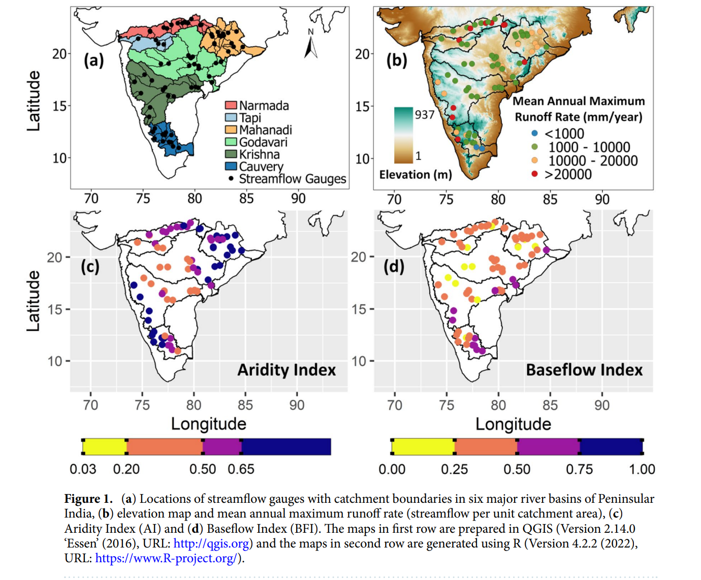
Narmada, Tapi, Mahanadi, Godavari, Krishna and Cauvery are six major river basins of Peninsular India. Tapi is the smallest river basin with an area of 65,145 km2 and Godavari is the largest which covers an area of 312,812 km2 . Narmada and Tapi are west flowing rivers that join the Arabian Sea, while other four are east flowing rivers which drain into the Bay of Bengal.
Godavari is the longest river of length 1465 km and Cauvery is the shortest river with a length of 560 km in Peninsular India. Narmada, lower and middle Mahanadi, Krishna upper sub-basin, Tungabhadra upper sub-basin and Cauvery upper sub-basin have high runoff rates. Peninsular catchments have semi-arid, dry sub-humid and humid climatic conditions.

Image Source: Shailza Sharma, P. P. Mujumdar (2024) Baseflow significantly contributes to river foods in Peninsular India, Nature Scientific Reports, 14, 1251.
Annual flood magnitudes have decreased in Peninsular catchments over the period 1979–2018. An increase in flood magnitudes is observed only in two catchments (Kurubhata and Kantamal) of Mahanadi river basin and one catchment (Dameracherla) of Godavari river basin while they are declining drastically in the Narmada river basin.
Study findings
Floods in Peninsular catchments are related to baseflows
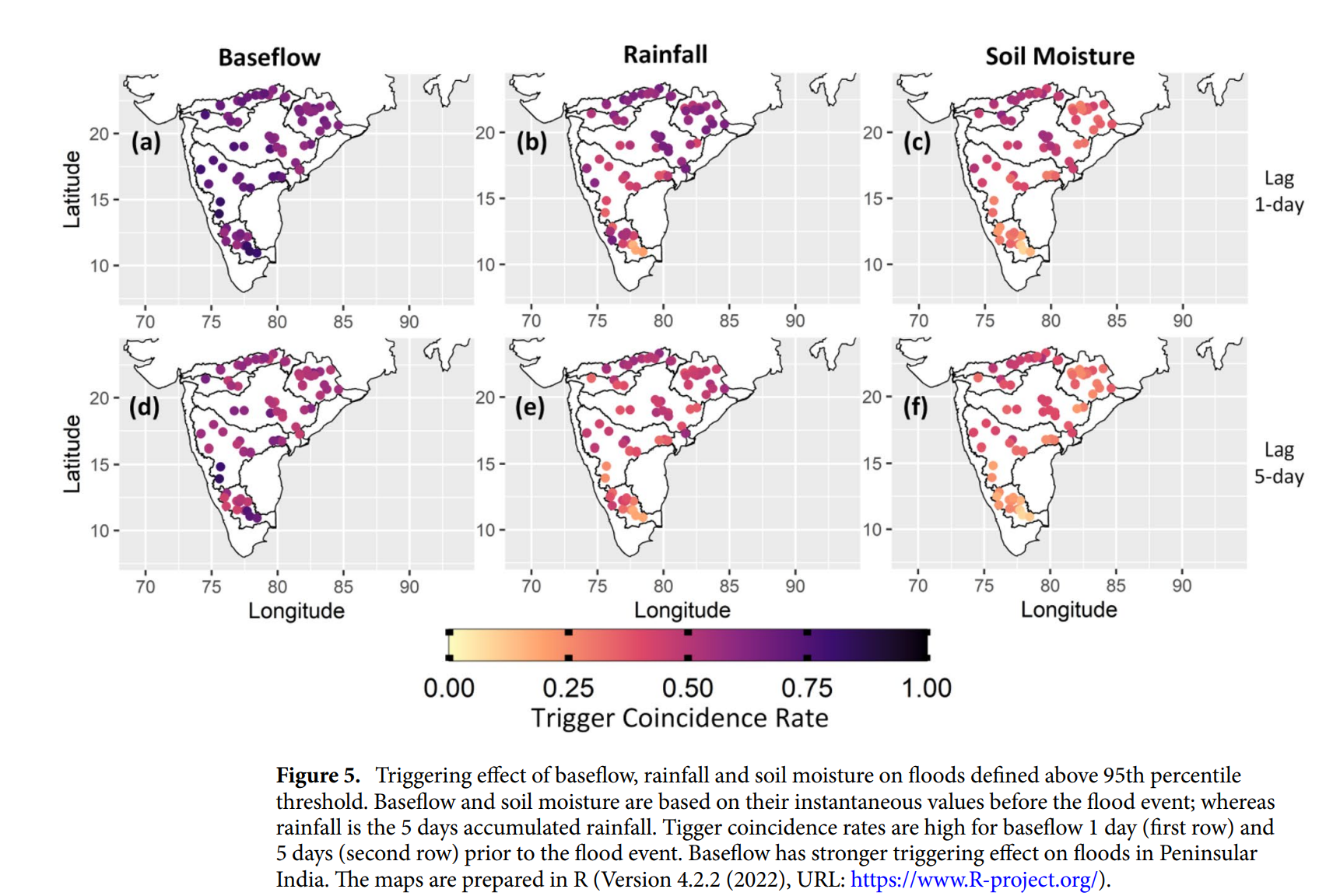
Flood magnitude trends show a strong association with trends in annual mean baseflows. Signs of flood magnitude trends are more consistent with the signs of trends in baseflow compared to rainfall and soil moisture. These results suggest that floods in Peninsular catchments are strongly correlated with baseflows compared to rainfall and soil moisture.

Image Source: Shailza Sharma, P. P. Mujumdar (2024) Baseflow significantly contributes to river foods in Peninsular India, Nature Scientific Reports, 14, 1251.
Dams have led to a significant increase in the flood duration in Peninsular catchments
Total 31 dams have been considered for the study. The study finds that reservoir regulations have a strong influence on flood characteristics. Reservoir regulation has increased the flood duration by up to 65 percent while it has reduced the peak flow and flood volume by~48.5 percent and~50 percent, respectively. This floods after the construction of dams last longer, but are less severe with reduced peak and volume in Peninsular catchments. These impacts are independent of the purpose of reservoirs.
The paper argues that more studies need to be done by looking at a combination of flood drivers and their combined effects on river flooding, as incorporating more information on the flood generating mechanisms is the key for improving flood predictions and plan better preventive measures.
/articles/baseflows-contribute-river-floods-peninsular-india