Technology

Water is life, essential for daily sustenance and healthy living. With plummeting groundwater levels, contamination of water sources and increasing consumption, challenges in the water sector have increased manifold. Safe, sustainable and affordable water in the face of growing water needs is a severe challenge. With fresh water supplies already hard pressed to meet growing demand, technology plays an important role in managing and using the limited available water in a cost effective and critical manner.

Water contamination occurs both due to human activities and natural processes. Depending upon the purpose for which the water is needed--municipal, industrial or agriculture--treatment is carried out. The technology used will depend upon the current water quality, future standards required and economics of the treatment method. Water treatment removes contaminants that may be biological, physical or chemical in nature. 

Various water treatment technologies are present that purify polluted water by removing undesirable chemicals or biological contaminants and making it fit for human consumption. Use based classification of surface waters in India has been laid down by the Central Pollution Control Board (CPCB). The details of the permissible and desirable limits of various parameters in drinking water as per Bureau of Indian Standards (BIS) standard specifications for potable water are also detailed in the IS 10500:1991

Water treatment plants use technologies to produce water that is safe both chemically and biologically, and that is appealing in terms of colour, odour and taste. The control point for water quality determination must be the consumer's tap and not the treatment facility, which means that the water quality must not be impaired during transmission, storage and distribution to the user. The treatment methods at the plant include aeration, coagulation and flocculation, sedimentation, filtration and disinfection.  Some of the prevalent water purification & treatment technologies are listed below.

  • Capacitive Deionization (CDI) is a technology where ions are removed from water by passing it through a spacer channel with porous electrodes on each side
  • Ozonation is a chemical water treatment technique based on the infusion of ozone into water
  • Ultraviolet technology uses Ultraviolet light, just like sunlight, to kill micro-organisms present in the water
  • Reverse Osmosis (RO) is a technology that removes a large majority of contaminants by pushing the water under pressure through a semi-permeable membrane
  • TERAFIL is a burnt red clay porous media used for filtration & treatment of raw water into clean drinking water, developed Council of Scientific & Industrial Research (CSIR), Bhubaneshwar 
  • OS- Community scale Arsenic Filter is an organic arsenic filter, developed by IIT Kharagpur
  • Filtration methods that may include rapid/ slow sand filters remove dirt, rust, silt, dust and other particulate matter from water
  • Solar water purification systems 

Water treatment technologies for safe, potable water in rural areas that includes Capacitive Deionization Technology (CDI) using carbon aerogel, solar operated groundwater treatment plants and electro chlorination are described in a booklet ‘Compendium of innovative technologies on rural drinking water & sanitation’ by the Ministry of Drinking Water and Sanitation. 

Domestic drinking water filtration methods vary depending upon the method of purification used, the degree of ‘purity’ required, and the type of contaminants in the water. No one technology will fulfil all criteria--there is no ‘silver bullet’ solution. Some of the more popular methods for Household Water Treatment & Safe Storage (HWTS) options includes boiling, SODIS (Solar disinfection), Chlorine Tablets, Liquid Chlorine (online, Biosand filters, Flocculent treatment, Ceramic candle, Filter combinations, Pureit filters, Ultra Violet (UV) filters, Reverse Osmosis (RO) and Ion Exchange (IEX).

For more on water purification systems, click here.

Domestic Greywater Recycling Water filtration technologies

Any used water, other than sewage from toilet basins that exit a house or apartment complex, is referred to as sullage or greywater. This is mostly made up of water used in bathrooms and kitchens, constituting the bulk--nearly 60%-70%--of the total volume of water used in a day. 

Before underground sewerage was introduced in most cities, water followed a cyclical route. Water was drawn from dug wells within the premises. Refuse water from the bathrooms and kitchen was let out into the garden while water from the closets reached septic tanks. The soil treated the greywater and sent it back into the ground, thereby closing the household water consumption-reuse loop.

Contrary to popular belief, greywater is largely free from pathogens. As it is mostly made up of easily degradable organic waste and chemicals from cleaning products, it can be purified and reused in-situ with minimal effort. In many homes and apartment complexes, sending this perfectly reusable resource out of the plot along with sewage common-sight. Greywater can be brought back into the water cycle by employing simple biological and mechanical filtration techniques.

There are two basic requirements apart from the necessary plumbing arrangements for treating domestic wastewater:

  1. Open soil space
  2. Water loving plants

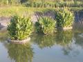
Water from bathrooms and kitchens can be diverted through a dedicated pipeline into the plant bed set aside for the treatment process. Here, the nutrients present in the waste water are absorbed by water loving plants such as Canna or Cyperus while the soil bacteria polish off the organic waste from the water. 

  • Constructed wetlands – These wetlands are created to replicate the process of bio-filtration that occurs in a natural setting. Here, the water is purified using two media, the planted surface and the gravel bed underneath. 
  • Reed bed treatment plants – A smaller version of the constructed wetlands, reed beds are perfect for individual houses and smaller complexes.
  • Mechanical filtration – Mechanical systems such as sand filters and pebble flow systems can be used to help filter out waste from the water by separating the discernable solids from the liquid component. 
  • Lava filters – These pebble filters are a combination of both biological and mechanical systems where the stones act as support structures for microorganisms that help break down the waste. 

For more on the basics of rainwater harvesting and greywater recycling, refer Self reliance in water: A book by Indukanth Ragade.  

Sewage treatment--Municipal and Industrial

Waste water flowing out of urinals and toilet closets are referred to as ‘blackwater’ or sewage. Blackwater cannot be treated in the same way as greywater as the former contains a heavy pathogen load from the fecal matter suspended in it. Sewage from towns and cities flowing directly into water bodies is one of the major reasons for water pollution.

Municipal wastewater treatment plant, Yelahanka, Bangalore

While City Corporations are in charge of laying underground sewerage pipes to collect, channel and treat sewage, localities outside city limits have a greater responsibility of managing their own waste. Apartment complexes and townships mostly rely on small scale sewage treatment plants (STP) to treat their waste.

Wastewater can be treated either in the presence or absence of oxygen. While aerobic digestion involves the breakdown of waste by microorganisms in the presence of oxygen, anaerobic systems work in its absence. Various types of processes are used to treat both domestic and industrial waste water such as:

  • Activated Sludge Process where biological agents such as bacteria are used in the presence of air to oxidise the nutrients present in the sewage 
  • Sequencing Batch Reactors help equalize, aerate and sediment waste water in timed batches by mixing it with activated sludge and oxygen to reduce the organic load 
  • Membrane Bio Reactors provide a higher degree of organic and solid removal by combining the principles of both mechanical filtration and biological digestion to treat municipal waste 
  • Moving Bed Bioreactors are mainly used for aerating and treating high-strength wastewater where several floating polyethylene bio-films move in suspension provide surface area for the nutrient-digesting bacteria to grow 
  • Trickling filters are low-cost, aerobic systems made up of a fixed bed of gravel, rocks and moss over through sewage is passed to remove the nutrient material in the suspension 
  • Facultative aerated lagoons are shallow ponds where the sewage is allowed to with the atmospheric oxygen in the upper layers while the sludge settles down at the bottom 
  • Waste stabilisation ponds, categorized into three broad types – anaerobic, facultative and aeobic depending on the oxygen use intensity – help in reducing nutrient content and polishing waste water to re-use quality 
  • Up-flow anaerobic sludge blanket digestion treats wastewater in the absence of oxygen where the feed enters the tank through the bottom and flows upward as the bacteria present in the sludge digest organic the matter 

The CPCB publication on the status of sewage treatment in India throws light on the performance of sewage treatment plants across the country and the technologies currently being used in them. The status of waste water generation and treatment across the country is also available on the ENVIS Centre on hygiene, sanitation, sewage treatment systems and technology. 

Term Path Alias

/topics/technology

Featured Articles
July 15, 2024 Kritsnam where engineering meets hydrology, founded by K. Sri Harsha focuses on developing accurate, easy to install, tamper-proof, and weather-proof smart water metering solutions to deal with the growing water crisis in India.
An AI generated image, highlighting water shortage and use of tankers to provide water but water being wasted when available (Image Source: Praharsh Patel)
June 9, 2024 India’s funding jumped from $225 million in 2018 to $1.5 billion in 2023, marking a compounded annual growth rate of 140%
Green startups: Powering a sustainable future (Image: Needpix)
May 19, 2024 The surprising connection between Wikipedia, beaches, and your water bottle.
A top down image of a lush green forest in a sacred grove in Meghalaya (Image created by: Sreechand Tavva)
May 6, 2024 In our quest to spotlight dedicated entrepreneurs in the water sector, we bring you the inspiring story of Priyanshu Kamath, an IIT Bombay alumnus, who pivoted from a lucrative corporate career to tackle one of India's most intricate water quality challenges, that of pollution of its urban water bodies.
Innovative solutions to clean urban water bodies, Floating islands (Photo Credit: Priyanshu Kamath)
March 6, 2024 A journey into a Geo-AI platform with Jagriti Dabas, Founder of Arms4AI
Jagriti Dabas's firm Arms4AI leverages deep technology and GEO-AI to automate satellite based image analysis (Image: Arms4AI)
January 30, 2024 The workshop provided inputs into the newly formed committee for “Standard Operation Procedure for Quality Testing of Drinking Water Samples at Sources and Delivery Points”
Sector partners come together to supplement the efforts of the government on water quality and surveillance (Image: Barefoot Photographers of Tilonia)
Modeling of flow in the canal due to breach of bank - A research report by National Institute of Hydrology
The study develops the wavelet element method for hydrological application purposes in general and modeling of flow in a canal due to breach of bank because of rainfall and cyclones. Posted on 27 Jun, 2010 12:15 AM

The study develops the wavelet element method for hydrological application purposes in general and modeling of flow in a canal due to breach of bank in particular. Due to high seasonal variability of rainfall and cyclones in coastal India, flood discharges cause frequent breaching of canals.

Canal breach modeling is of great significance in open channel hydraulics. The study of breach of a canal is a relatively new one as compared to dam breach, which is a well researched field. The analysis of the problem is complicated due to dynamics of flow within the canal. The limitations of the above model due to the one-dimensional model analysis of the problem is hoped to be overcome in two or three dimensional analysis.

Flood control regulation of a multi-reservoir system - A research report by National Institute of Hydrology
The report describes the software, which has been developed for flood control regulation of a system of reservoirs. Posted on 26 Jun, 2010 01:41 PM

The report describes the software, which has been developed for flood control regulation of a system of reservoirs. The reservoirs can be gated or ungated, and the system can have any combination including weirs and diversions. For operation of reservoirs, the scenario has been divided into two categories depending on the reservoir level and inflows - normal operation and emergency operation.

The input data requirements of the software are modest. This software along with previously developed software for conservation operation would provide a complete set of tools to analyze any system configuration for the range of purposes for which reservoirs are commonly built in India.

Application of Geomorphological Instantaneous Unit Hydrograph and Geographical Information Systems based approach for flood estimation – A research report by National Institute of Hydrology
The study attempts to apply Geomorphological Instantaneous Unit Hydrograph (GIUH) and Geographical Information Systems (GIS) based approach for flood estimation Posted on 25 Jun, 2010 10:33 PM

The study attempts to apply Geomorphological Instantaneous Unit Hydrograph (GIUH) and Geographical Information Systems (GIS) based approach for flood estimation. The design storm data of four catchments along with morphological characteristics have been considered. The geomorphological parameters and time area diagrams for each of the dam catchments were generated using the GIS package, Integrated Land and Water Information Systems (ILWIS).

The geomorphological parameters together with the time-area diagram forms an important input for the GIUH based Clark model. This model has been applied for deriving the instantaneous unit hydrograph and thereby to estimate the design flood in four dam catchments located in Luni and Chambal basins in Rajasthan viz. Jawai, Sei, Gamabhiri and Alnia. A review of the previous studies carried out using GIUH approach has been presented. Furthermore, a review of studies carried out using GIS techniques is also provided.

Hydrological problems of hard rock regions: A state of art report by the National Institute of Hydrology
The study presents a status report on hydrological problems of hard rock areas related to hydrological network design, groundwater quality, failure of open and borewells. Posted on 25 Jun, 2010 07:32 PM

The study presents a status report on hydrological problems of hard rock areas related to hydrological network design, groundwater quality, failure of open and borewells, regional flood formulae, groundwater balance studies, reservoir sedimentation, hydrological aspects of droughts, forest hydrology and drainage problems of black soil of the hard rock terrain.

Snow and glacier contribution in the Satluj river at Bhakra dam - A research report by National Institute of Hydrology
The study estimates the average contribution of snow and glacier melt runoff in the annual flow of Satluj river at Bhakra dam. Posted on 25 Jun, 2010 12:07 AM

The study estimates the average contribution of snow and glacier melt runoff in the annual flow of Satluj river at Bhakra dam. This study is restricted to the Indian part of Satluj basin. A water balance approach was used to determine the average snow and glacier contribution to the annual flows.

Study of Lake Nainital: Groundwater interaction using Isotope techniques - A research report by National Institute of Hydrology
The study undertakes hydrological investigations to develop a conceptual model for the water balance of Lake Nainital in Kumaon Himalayas. Posted on 25 Jun, 2010 12:03 AM

The study undertakes hydrological investigations to develop a conceptual model for the water balance of Lake Nainital in Kumaon Himalayas. All the components of lake water balance, except the sub-surface ones, have been measured or estimated using standard methods like isotope mass balance method in conjunction with the conventional water balance method. The sub surface outflow from the lake was assessed by studying the hydraulic interconnection of the lake and downstream springs using environmental tracers.

Changes in land use and land cover and establishment of SCS runoff Curve Number in Suddagedda basin – A research report by National Institute of Hydrology
The study was taken up as a part of the representative basin studies being done by NIH and involved hydrological land use & land cover mapping for the Suddagedda basin of Andhra Pradesh. Posted on 24 Jun, 2010 11:52 PM

The study was taken up as a part of the representative basin studies being done by NIH and involved hydrological land use & land cover mapping for the Suddagedda basin of Andhra Pradesh. Mapping was carried out through visual interpretation for the years December 1987, April 1989, December 1992 and November 1996 using IRS IB-LISS II, LANDSAT 5-TM and IRS IC-LISS III data.

Land use and land cover are the most important surface characteristics of a basin. They are very dynamic features over space and time and it is difficult to get real time information on them through conventional means. Planners need to update knowledge of natural resources, which can be obtained quickly, economically and accurately through remote sensing techniques. Further, the land use map of a basin or region provides hydrologically significant categories, which are essential for estimation of reliable runoff from ungauged basins.

Groundwater quality monitoring and evaluation in Jammu and Kathua districts (Jammu & Kashmir) - A research report by National Institute of Hydrology
The study evaluates groundwater on the basis of widely used graphical methods like Piper, Stiff and US Salinity Laboratory classification. Posted on 23 Jun, 2010 11:55 PM

The study evaluates groundwater on the basis of widely used graphical methods like Piper, Stiff and US Salinity Laboratory classification. The study concludes that, in general, the groundwater in the area varies from medium salinity to very high salinity, the latter being more common in the irrigated stretches. The irrigators are advised to ensure good land and water management practices in the fields, with particular emphasis on creating favorable leaching and drainage conditions to avoid further development of saline conditions in the area. 

Spatial variability of groundwater quality in Jammu district - A research report by National Institute of Hydrology
The study applies geostatistical techniques to the groundwater quality data of December 1994 in parts of Jammu district. Posted on 23 Jun, 2010 10:58 PM

The study applies geostatistical techniques to the groundwater quality data of December 1994 in parts of Jammu district. Groundwater quality deterioration has led to considerable interest in the design of investigative studies and monitoring programs on the issue.

Various management measures need to take into account the spatial and temporal behavior of groundwater. The spatial dependence between observations can be expressed by semi variance, which is a measure of the average similarity between observations at a given distance apart. One of the prime reasons for obtaining a semivariogram is to use it for estimation of the variable at unsampled locations.

Capacity evaluation of Bhakra reservoir using digital analysis of satellite data - A research report by National Institute of Hydrology
The study assesses sedimentation rate, water spread area and volume of the Bhakra reservoir in Satluj basin using remote sensing data for the years 1988-89 and 1996-97. Posted on 23 Jun, 2010 10:48 PM

The study assesses sedimentation rate, water spread area and volume of the Bhakra reservoir in Satluj basin using remote sensing data of IRS-1B satellite and LISS-II sensor data of the years 1988-89 and 1996-97. The original elevation-area capacity curves and the reservoir levels on the eight dates of pass of the satellite were obtained from the Bhakra Beas Management Board, Nangal.

Using the trapezoidal formula, the capacity in between the maximum (513.904 m) and minimum (450.436 m) observed levels was assessed for the year 1996-97. The loss of capacity till 1988-89 was 491.315 mcum and till 1996-97 was 807.354 mcum. These could be attributed to the sediment deposition in the zone of study of reservoir.

×