Rivers

Term Path Alias

/topics/rivers

Featured Articles
April 18, 2024 As the demand for water from the Hindu Kush Himalaya region is expected to rise due to population growth, the impacts of temperature increases, and development requirements, researchers emphasise the urgent need to enhance scientific collaboration and rejuvenate existing treaties and governance structures.
Rivers of destiny (Image: Vikramjit Kakati/Wikimedia Commons; CC BY-SA 3.0 DEED)
February 20, 2024 This study predicts that sewage will become the dominant source of nitrogen pollution in rivers due to urbanisation and insufficient wastewater treatment technologies and infrastructure in worse case scenario projections in countries such as India.
The polluted river Yamuna at Agra (Image Source: India Water Portal)
October 16, 2023 अब वह दिन दूर नहीं कि गंगाजल की तरह सरयू जल को भी बोतल में सुरक्षित किया जा सकेगा और वह खराब नहीं होगा।सरयू नदी में पाए जाने वाले जीवाणु एवं विषाणुओं पर अध्ययन हेतु विज्ञान एवं प्रौद्योगिकी मंत्रालय के विज्ञान एवं अभियांत्रिकी विभाग की आर्थिक सहायता प्राप्त की है। इनके निर्देशन में शोध छात्रों द्वारा अस्पताल में संक्रमण करने वाले जीवाणुओं की पहचान और उनकी एंटीबायोटिक प्रतिरोधी बनने पर अध्ययन किया जा रहा है।
गंगा नदी,गंगोत्री
October 8, 2023 While the current push for legal personhood for rivers is facing obstacles and is stalled, it holds potential as a viable long-term strategy for the preservation of India's rivers
River quality deteriorates as demand for hydropower to support economic growth continues to expand. (Image: Yogendra Singh Negi, Wikimedia Commons; CC BY-SA 4.0 DEED)
July 18, 2023 पश्चिमबंगाल पंचायत चुनाव-2023 में पर्यावरण एक बड़ा अहम मुद्दा बना। नदी और पर्यावरण राजनीतिक दलों के एजेंडे से कहीं अधिक आम लोगों के आकर्षण का केन्द्र बने।
पश्चिमबंगाल पंचायत चुनाव
June 17, 2023 सहस्त्रधारा-बाल्दी नदी के किनारे के धनौला गांव में नदी पर अवैध निर्माण गतिविधियों के मुद्दे को सबसे पहले याचिकाकर्ता मीनाक्षी अरोड़ा ने उठाया था, जिनका इस साल 6 मार्च 2023 को निधन हो गया। उनके पति केसर सिंह अब सहस्त्रधारा-बाल्दी नदी मामले की पैरवी कर रहे हैं।

सहस्त्रधारा-बाल्दी नदी पर अतिक्रमण,फोटो सभागार:- केसर सिंह
Basin maps of Godavari river showing basin indicators, landcover classes and biodiversity information and indicators
World Resources Institute presents basin maps of Godavari river showing basin indicators, landcover classes and biodiversity information and indicators Posted on 17 Apr, 2009 12:42 PM

Map of Godavari Basin Basic Indicators

Basin indicators map of Godavari river basin

Basin maps of Ganga river showing basin indicators, landcover classes and biodiversity information and indicators
World Resources Institute presents basin maps of Ganga river showing basin indicators, landcover classes and biodiversity information and indicators Posted on 17 Apr, 2009 11:08 AM

Ganga river basin

Basin maps of Tapti river showing basin indicators, landcover classes and biodiversity information and indicators
World Resources Institute presents basin maps of Tapti river showing basin indicators, landcover classes and biodiversity information and indicators Posted on 17 Apr, 2009 10:37 AM

Basic Indicators of Tapi Basin

Basin indicators map of Tapti river basin

Compilation of data for Cauvery basin for river basin planning along with maps of major river basins of India
River basin planning allows observation of all relevant parameters in a basin in an integrated manner Posted on 17 Apr, 2009 09:49 AM

Water flows without regard to political and administrative boundaries. Water planning with respect to rivers should therefore be done for the river basin (or sub-basin) as a whole. River basin planning also has to look in an integrated way at all the relevant parameters like urban and rural populations, water usage patterns, water pollution, wastewater flows.

Cauvery basin: its culture, places of historical significance, birth place, climate, precipitation, catchment, tributaries, state-wise spread, landuse
The article describes the journey of Cauvery river from its birthplace Talakaveri to Bay of Bengal alongwith climate, landuse, distribution and water quality pattern of the basin Posted on 14 Apr, 2009 12:21 PM

Culture and places of historical significance

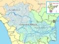
The river Cauvery has been the inspiration for various civilizations who have thrived on the banks of the river. This can be seen manifested in the various forms of art, culture and philosophy that have originated along the course of the river.

Kosi Katha - The making of a famine': Video highlighting the growing famine in the wake of the floods in Bihar
This video from Janmadhyam highlights the plight of those regions badly hit by the recent floods in Bihar where the ugly threat of famine is looming large Posted on 14 Apr, 2009 04:05 AM

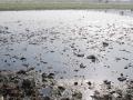
The latest loss figures (24 Feb. 09 is five districts, 35 blocks, 33.29 lakh peopla, 9.97 lakh live stock., affected area 3.68 lakh hectares, 2.37 lakh houses, 527 human death a and 19,323 loss of cattle.

Hydroelectric power projects & climate change: A case study of Ravi basin in Himachal Pradesh
The Role of Hydroelectric Power Projects in the Climate Change: A Case study of Ravi basin in Himachal Pradesh Posted on 09 Apr, 2009 11:34 AM

The following is a paper by Dr. Mohinder Slariya based on data collected during his Ph.D work. The work contains data sourced from the India Water Portal, and aims to illustrate local area climate changes with the development of hydroelectric projects. The abstract of the paper has been quoted below, with the full paper available as a download!

Abstract

Dams have had serious impacts on the lives, livelihoods, cultures and spiritual existence of indigenous, tribal and illiterate people, moreover on the physical environmental conditions and on the biodiversity of the area concerned. The dam related developmental activities in Ravi catchment area have been threatening the biodiversity in the whole catchment. There are more than 50 rivulets in the Ravi catchment and on which more than 70 power projects have been planned by the government by putting biodiversity at the stake. Developmental activities have unintentionally produce weather and climate modifications on a larger scale and threaten the existing biodiversity. Such developmental activities have been started day back in 1980s in Ravi basin with the installation of Baira Suil Power Project and today it has covered all most all Ravi basin starting from interstate broader of Jammu & Kashmir, Punjab and Himachal Pradesh and engulfed the green cover of the area. Because of this extinction the catchments area is experiencing drastic climatic changes, because of 100 km reservoirs of Shahpur Kandi (125MW), Thein Dam (600MW), Chamera-I (540MW) and Chamera-II (300 MW) and tunnelization of Ravi in 19.38 kms with a dia of 7 to 9 meters and 102 meters high surge shafts with 15.5 meters dia and underground power houses of Chamera-I & II and dry Ravi in almost all its natural route (27 kilometers in Chamera I & II). In this dry region there is a tremendous increase in the temperature and there is no timely and usual rain in the basin after the installation of power projects.

Kosi darshan: A deeper look at the lives of those pinned on the river
Dinesh Mishra paints a riveting picture of the state of the villages whose future remains closely intertwined with the Kosi, both in India and Nepal Posted on 31 Mar, 2009 05:14 PM

"If it had not breached at Kusaha, it would have anyway breached at this point," points a villager towards the probable location on the eastern bank in village Rajabaas near Prakashpur in Sunsari district of Nepal, located 14 km upstream of Kusaha where the Eastern Afflux embankment of the Kosi had breached on the August 18, 2008.

Invitation: Orissa River Conference in Sambalpur, April 18 - 20,2009, Water Initiatives Orissa
Posted on 31 Mar, 2009 11:46 AM

The Orissa River Conference is being held from April 18 - 20, 2009, Sambalpur, Odisha.

India River Network (IRN) and Water Initiatives Orissa (WIO) invite you to a three day long Orissa River Conference. Rivers are in stress and dying. Odisha is no exception. All of its rivers including major rivers Mahanadi, Brahmani are dying of quantitative and qualitative degradation and decrease. Water salinity in the lower Brahmani has gone up as river flow has almost stopped in crucial summer months. Water flow in the Mahanadi River too is decreasing at a rapid rate. A comparison between second half of the post Hirakud dam period with the first half shows about 15 percent of decrease in average annual flow. Other rivers like Baitarani, Subarnarekha, Vanshadhara, Rushikulya and Nagabali etc. are also suffering the same fate. The problems are manifold. Unsustainable growth of population; industrialization led pollution; climate change and many other problems have virtually wrecked havoc on the fate of the rivers. The rivers are dying and are surely spelling doom for the civilizations around them.

Request for photographs on dams for publishing in FlyLite magazine
Posted on 19 Mar, 2009 10:29 AM

Send to the Portal by Divya Mishra Assistant Editor FlyteLite ========== I handle a magazine called FlyLite (which is the in-flight magazine for JetLite) and for our April issue, we're carrying a story on the dams and bridges of India. We are currently looking for images for the following structures: 1. Gandhi Setu, Patna 2. The Grand Anicut Dam, Tamil Nadu 3. Idukki Dam, Kerala 4. Hirakud Dam, Orissa 5. Krishna Raja Sagara Dam, Karnataka

×