Term Path Alias
/topics/droughts-and-floods
/topics/droughts-and-floods

![]()
![]()

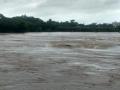
This initiative is an attempt to provide daily updates on Flood Situations and related events/news to water enthusiasts, professionals and citizens concerned about flood in Odisha. News and information collected from Odia news papers, English media (internet editions) and web site of Department of Water Resources, Govt of Odisha are put together at one place to provide an overview of flood in Odisha on a daily basis.
![]()
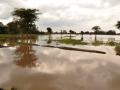
This initiative is an attempt to provide daily updates on Flood Situations and related events/news to water enthusiasts, professionals and citizens concerned about flood in Odisha. News and information collected from Odia news papers, English media (internet editions) and web site of Department of Water Resources, Govt of Odisha are put together at one place to provide an overview of flood in Odisha on a daily basis.
Floods: lessons to be learnt from the massive flooding in Surat city
A report by IIM criticises the way in which dams are managed in the country and calls for the need to apply Management Science / Operations Research techniques and information technology to improve dam management and prevention of floods
The study deals with flood plain mapping in a part of Yamuna basin between Gangoh and New Delhi. A flood is a markedly high stage of flow in a river and may inundate adjoining lands, which is called the floodplain of a river. So, floodplain is land inundated by a flood of given frequency. Alternately it is also defined as flat land between valley walls.
In this study, HEC 2 programme has been implemented on river Digaru to compute flow regime or the water surface profile for various discharge conditions. In this reach, two bridges have been considered to compute water surface elevations, critical water surface elevations, energy grade elevations & slope, velocity in the channel, flow area, top width and Froude Number.
![]()
![]()
We had mentioned while dispatching our 1st Issue of River Basin Transact that the present pace and direction of development bandwagon in Odisha, made it imperative for its civil society and citizens alike to give more attention to its rivers, before it became too late.
During this quarter (Apr-Jun), there are quite a few such civil society responses towards redefining the way our rivers are being managed. While Dakshin Odisha Vikash Parishad (DOVP) came up with a suggestion to have Integrated River Valley Project in line of TVA in USA to manage South Orissan Rivers, State Govt resolved not to allow any new industry to draw water from the Brahmani and the Baitarani. Towards the end of the quarter alignment of civil society and political parties around MBA (Mahanadi Banchao Andolan) to protest diversion of Mahanadi water to POSCO and IOC made the headlines local dailies.
The study deals with dam break analysis of Barna dam located in the state of Madhya Pradesh carried out using the popular National Weather Service Dam Break Flood Forecasting (NWS DAMBRK) model to assess the likely maximum flood discharge and elevation to be attained in Bareli township, 22 km downstream of the dam.
The report presents flood plain mapping of Phulbari area within the flood plains of Brahmaputra basin in the States of Assam and Meghalaya using satellite data. Flood is a natural calamity in which most parts of the north-eastern region are ravaged. Management of the problem in these disastrous flood affected areas often requires flood plain mapping for protection and resource development. This has mostly being done in real time on the basis of time consuming and often hazardous ground based surveys.
The report deals with determination of SCS runoff Curve Number and land use changes for Hamidnagar sub-basin of Punpun basin. The design of any hydraulic structure calls for the estimation of runoff. The Soil Conservation Services model, developed by USDA, computes direct runoff through an empirical equation that requires the rainfall and watershed coefficient as inputs. The watershed coefficient is called the Curve Number (CN), which represents the runoff potential of the land cover-soil complex.
dear all, I have sent several mail to concern department including minster jairam romesh regarding the Protecting PILI river , due to filling pond , taal , river land , dam to a river land encroachment in my village KOPA , Unfortunately, I still haven't received my reply .