Term Path Alias
/sub-categories/data
/sub-categories/data
This report by ICRISAT deals with a survey of thirty-two tanks and farm data from Andhra Pradesh and Maharashtra states to assess the economic performance of irrigation tanks in semi arid tropics of India. It uses district-wise data on climatic and institutional variables to analyze the factors affecting tank-irrigation density. Results indicate that the spatial distribution of irrigation tanks is determined primarily by physical factors—hard rock substratum, post-monsoon rains, low moisture-holding capacity of soils and by population density.

I was going through weather data exposed by India Water Portal and I was thinking about an interesting application which would show my love to Bangalore. The best part of Bangalore is its temperature, rains and clouds. So I wrote this small app which uses the data provided by India Water Portal (which in turn is by CRU). IWP has data for all the districts in India, for every month and for multiple parameters. They have data for 100 years. It quite an amount of data to play with if you are interested. They have an easy way of filtering and downloading.
Flood forecast alerts are provided by Central Water Commission. They have boring maps and tables. Also they don’t provide data in program accessible format. Members of ICTD for asia are working on parsing and storing that data. In the meantime I wanted something to play. I found ScraperWiki (hacker news discussion) which can be used to scrape data from any page and schedule it for running. It allows php, python and ruby languages. Its easy and gives lot more flexibility than Y! pipes to scrape that data. Here is my scraper to get the flood data. You will have to register to get an API to use the data. Data is available in JSON, XML, PHP etc.
After watching “developing world” video on TED, I was eager to try out Google visualization API. When I found the rain fall information, I thought its the best suited data to play around. Go check out the Visualization of Rain Fall in Karnataka.
These presentations by ACWADAM deal with the application of remote sensing and aerial photography techniques in groundwater management. Remote sensing is a technique by virtue of which information about an object, area or phenomenon is obtained with the help of a sensor on board a platform from distance without coming in contact with object, area or phenomenon.
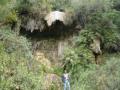
This presentation by ACWADAM deals with Karst hydrogeology, a term used to denote the topography over limestones, dolomites or gypsum rich rocks where there are sinkholes, caverns and lack of surface streams. Karst mainly refers to carbonate rocks: Limestones (CaCO3) or Dolomites (MgCa[CO]).
The formation of carbonate rocks can be traced to physical and chemical deposition. Physical deposition is clastic in nature formed by deposition of particles carried in suspension. It is marked by higher primary porosity and low secondary porosity. Chemical deposition is in the form of precipitate formed by deposition of particles from solution. Contrary to physical deposition it is marked by low primary porosity and high secondary porosity.

In order to maintain the ecological goods and services of rivers and other hydrological regimes like wetlands, lakes, etc., environmental flow allocations (eflows) are a necessity. At the same time, water demands in India are increasing and will keep increasing and solutions like waste water treatment, pollution control, correction of leakages and wastage of water, efficient irrigation systems, efficient agricultural systems, etc., will take considerable time to evolve, even with our best efforts. So what should we do in the meantime? There are vulnerable ecological systems on the verge of collapse..How do we respond to these challenges?
This study by the National Institute of Hydrology deals with simulation of soil moisture movement and determination of groundwater recharge from rainfall in Barchi watershed in the hard rock region of Karnataka using the numerical model, Soil Water Infiltration and Movement (SWIM).
A peer paper in Science Magazine focuses on the core of a riverine system, the upstream basin, and its impact on the entire river basin.
