Term Path Alias
/regions/nepal-himalayas
/regions/nepal-himalayas
For more information on the organisers, ICIMOD, please click here.
Details of the conference may be viewed here.
For programme details, click here.

![]()
Organiser details

The second edition of the book came out in 2008 just after the devastating Bihar floods in the year when the river thundered down from the Himalayas on its way to the sea sweeping half of Bihar.
The general objectives of the assessments were:
The HKH region is one of the most dynamic, fragile, and complex mountain systems in the world as a result of tectonic activity and the rich diversity of climates, hydrology, and ecology. The high Himalayan region is the freshwater tower of South Asia and has the highest concentration of snow and glaciers outside the polar regions giving it the name Third Pole.

Balati glacier, Pithoragarh district, Uttarakhand (Source: Uttarakhand and I)
The Hindu Kush-Himalayan region has had very few resources to develop a detail scientific understanding needed to assess climatological, environmental, and other data in the past and there is very little information upon which a baseline for comparison with the present can be formed and future impacts can be anticipated.
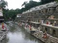
Bagmati river in Kathmandu: From holy river to unthinkable flowing filth
")
Ajaya Dixit initiated his presentation with a general account of how rivers shape the landscape and how riverine ecosystems have nurtured society and kept civilisations vibrant, cultured and creative. Dixit went on to discuss the basin characteristics of the Bagmati, a tributary of the Kosi that rises in the Shivapuri hills, north of the Kathmandu valley. Around fifteen percent of the basin area (3700 sqkm) lies in Nepal, while the remaining is in India. The average annual rainfall in the basin is 1400 mm and is more than 2000 mm in the hills. Bagmati is a seasonal river with rainfall and springs as its main source. Its mean flow is 15.6 cubic metre/second and low flow is 0.15 cubic metre/second in April.
Kathmandu lies in the Upper Bagmati basin and studies suggest that an ancient lake called the Paleo-Kathmandu lay within the Kathmandu valley as a lacustrine formation. Early settlers lived in lower slopes and used springs and river in the upper reaches. When they moved to the valley floor, they built dongia dharas, which are stone water spouts fed by the unconfined aquifers and delivered water through surface channels. Even today, dongia dharas dated back to 1500 years exist. The state built canals (raj kulo) tapped the upper stretches of the rivers close to the mountains. Rivers and irrigation helped recharge aquifers and ponds.
However, rising urbanisation has damaged these ancient artifacts. Over the last sixty years Kathmandu has expanded massively and its population has increased from 0.41 million in 1951 to 2.6 million in 2011. The city has a huge transient population aside from this, reducing it to a concrete nightmare. Seismologists suggest that Kathmandu is a rubble city in the making. Though the Bagmati river flow has not changed significantly in the last seventy years, the character of the river has been transformed significantly during the period 1970 to 1990. The river has been canalised while the dumping of the city’s garbage into it continues. Dixit identified a plethora of problems faced by the river such as upstream water diversion for drinking water needs, disposal of untreated liquid waste, disposal of solid waste, river jacketing for roads and commercial activities, sand mining and physical encroachment.
The state of the river is an outcome of the current approach to waste management particularly liquid waste management. Three types of waste water namely yellow water flux, grey water and yellow black flux are being generated and flowing water is being used as a vehicle to dispose these. The idea of a water based disposal system e.g. flush toilet embedded in Victorian engineering has led to a technological lock-in with the result that the notion of a natural hydrological cycle has undergone a fundamental transformation.
All the same, the bulk of the load in the river is biological though there are some factories releasing effluents. In the last 20 years some of them have been closed or relocated and the river now stands a chance of being salvaged.
The initiative on management of natural resources through appropriate interventions aimed at:
This report by the Task Force, constituted by the Planning Commission, Government of India in April, 2008, is an outcome of the need expressed by the Prime Minister of India for a fresh analysis of the problems of the hill states and hill areas of the country in a manner that suggests that these areas do not suffer in any way on account of their peculiarities.
Opinions have been expressed that the pace of development of the Indian Himalayan Region (IHR) has been slow when compared to the rest of the country. At the same time, its fragile nature and difficulty of taking up conventional development initiatives has not been appreciated. In this report, arguments have been presented recommending reshaping of policies to bring in the “mountain perspective” for the IHR, in the national planning. Emphasis has also been laid on developing norms for good governance and for harnessing social capital at the grassroots.
