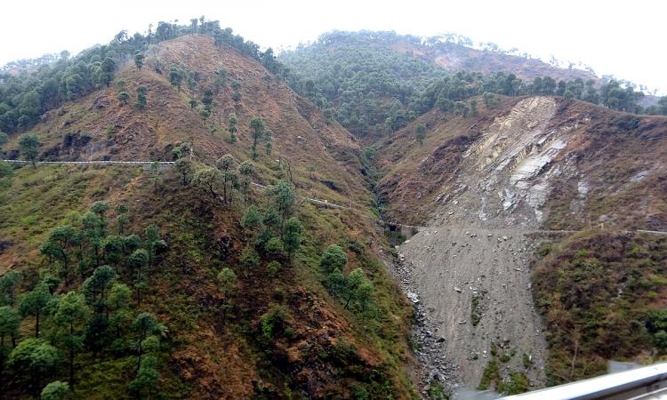
While Joshimath in the Himalayas was in the news this year for landslide events that caused massive damage to infrastructure and lives, the problem is not confined to Uttarakhand alone. Many states in India are seeing a marked increase in the occurrence of landslide events in recent years.
Landslides are one of the main natural catastrophes occurring in mountainous terrain and can lead to deaths among millions of people besides damaging property, infrastructure and disrupting communication.
Areas such as the western coastal parts of North and South America, Central America, Alpine regions of Italy, France, Switzerland and Austria in Europe, Himalayan regions of India, Nepal in Asia and parts Central Asia are more vulnerable to landslides mainly due to developmental activities done to meet the growing demands of the ever increasing population.
Landslides rank 3rd in terms of number of deaths among the top ten natural disasters world over and the regions with the highest landslide risk include Colombia, Tajikistan, India and Nepal.
Knowing what are landslides, their types, causes, the kind of destruction caused by them, vulnerable areas and the risks posed due to landslides is crucial to alert people before the landslide event occurs, devise coping mechanisms and plan strategies to prevent them and lessen/control their impacts on the population.
What is a landslide?
A landslide is defined as the movement of a mass of rock, debris, or earth down a slope. Landslides can be triggered by rain, earthquakes, volcanoes, or other events that make the slope unstable. Geologists, scientists often describe landslides as a type of mass wasting, which is any downward movement in which the Earth's surface is worn away [1].
Dirt, rocks and assorted rubble are often dislodged and pulled by gravity down a slope during a landslide. This is because of slope failure because the underlying earth holding the debris in place fails to maintain that hold. The speed and intensity of the landslide can depend on the kind of material being propelled downward and on the steepness of the slope. While landslides moving swiftly provide little warning and can cause severe damage, even slow moving ones can cause serious damage when the mass getting displaced is large [2].
Landslides may include rockfalls, deep-seated slope failures, mudflows and debris flows. They can occur in places with steep or gentle slopes - from mountain ranges to coastal cliffs or even underwater. Gravity is the primary driving force for a landslide to occur, but there are many driving factors that can affect stability that produce specific conditions that make a slope prone to failure such as a heavy rainfall, an earthquake, a slope cut to build a road, and many others, although this is not always identifiable [3].
Features of a landslide
The upper portion of a landslide is called as a scarp that has a steep slope and is considered to be the most important feature in landslide recognition. It is often semi-circular in shape and is perpendicular to the direction of the steepest part of the slide. The scarp changes into flanks, which form the landslide edges and appear perpendicular and downslope to the main scarp [11].
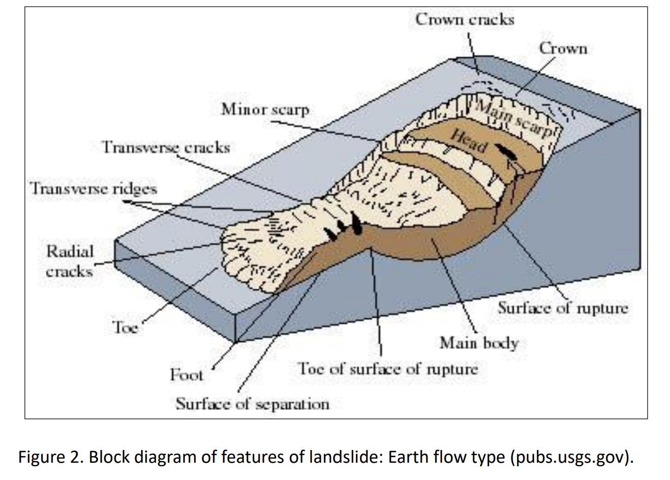
Image Source: NRSC (2023) Landslide Atlas of India.
The body of a landslide is the area where the depleted mass moves and this can create radial and transverse cracks. This zone also contains some minor scarps and appears very rough depending on the landslide body. The last part of the landslide is the toe, which is a curved margin of the displaced material and is located far from the main scarp [11].
Read more about the features of a landslide here
How are landslides classified?
|
Type of movement |
Bedrock | Course soil | Fine soil | |
|---|---|---|---|---|
| Fall | Rock fall | Debris fall | Earth fall | |
| Topple | Rock topple | Debris topple | Earth topple | |
| Slide | Rotational (slump) | Rotational Debris Slide | Rotational Earth Slide | |
| Translational | Translational rock slide | Translational Debris Slide | Translational Earth Slide | |
| Lateral spread | Rock spread | Debris Spread | Earth spread | |
| Flow | Rock flow (deep creep) | Debris Flow (Soil Creep) | Earth flow (Soil creep) | |
| Complex | Combination of two or more principle kinds of movements |
Table Source: National Remote Sensing Centre, ISRO (2023) Landslide Atlas of India [4]
The recently published Landslide Atlas of India by National Remote Sensing Centre, ISRO [4] classifies landslides by type of movement, material and flow.
- Types of movement
- Falls: Due to rocks and boulders that get detached from steep slopes or cliffs
- Topple: Forward rotation of a mass of debris or rocks from a slope.
- Slides: Downslide of material that occurs along a slip surface.
- Rotational slide: Slide about an axis which is parallel to the ground surface and transverse across the slide.
- Translational slide: Landslide mass moves along a planar surface with rotation or backward tilting [4].
- Types of Materials
- Rock: hard or firm mass.
- Debris: Includes material where 20 to 30 percent of it is larger than 2mm, and the rest lesser than 2mm.
- Earth: material in which 80 percent or more of the particles are smaller than 2mm.
- Soil: an aggregate of solid particles, generally of minerals and rocks.
- Mud: material in which 80 percent or more of the particles are smaller than 0.06mm [4].
- Types of flows
- Debris flow: A rapid mass movement of loose soil, rock, organic matter, slurry downslope caused by heavy rainfall or rapid snow melt.
- Earth flow: Rapid flow of fine grained material saturated with water down a slope.
- Mudflow: A flow of wet or viscous fluid mass of fine and coarse grained material rapidly along drainage channels.
- Creep: slow, steady, downward movement of material under gravity in a large area.
- Lateral Spreads: lateral movement occurring along gentle slopes or flat terrain caused by liquefaction due to disasters such as earthquakes [4].
Further details on the structure and types of landslides can be found in the handbook at this link
What causes landslides?
Landslides can occur when forces acting down-slope (mainly due to gravity) exceed the strength of the earth materials that compose the slope. Landslides can thus occur on slopes weakened due to rainfall, snowmelt, changes in water levels, erosion due to streams, changes in groundwater levels, earthquakes, volcanic activity, disturbance by human activities, or a combination of these factors. Earthquakes can also induce landslides underwater called submarine landslides that can sometimes cause tsunamis [5].
Thus, landslides can occur due to:
- Saturation due to rain water infiltration or snow or glacial melt
- Rise in groundwater levels leading to increase in pore water pressure (e.g. due to aquifer recharge in rainy seasons, or by rain water infiltration)
- Increase of hydrostatic pressure in cracks and fractures;
- Absence of vegetation or soil structure
- Erosion of the top of a slope by rivers or sea waves or due to climatic factors such as physical and chemical weathering due to freezing and thawing, heating and cooling, salt leaking in the groundwater or mineral dissolution;
- Hazards such as earthquakes, or volcanic eruptions which can destabilize the slopes directly or weaken the material and cause cracks [6].
Landslides are aggravated by human activities, such as:
- Deforestation, cultivation and construction;
- Vibrations from machinery or traffic; blasting and mining;
- Removal of deep-rooted vegetation that binds colluvium to bedrock;
- Agricultural or forestry activities (logging), and urbanization, which change the amount of water infiltrating the soil.
- Land use and land cover changes that includes the human abandonment of farming areas etc
- Land degradation and extreme rainfall [6]
Do landslides happen in India?
Yes, India is among the top four countries with highest landslide risk and approximately 0.42 million sq. km or 12.6 percent of land area, excluding snow covered areas, is prone to landslides in the country [4].
Of this, 0.18 million sq. kms fall in the North Eastern Himalayas, including Darjeeling and Sikkim Himalayas; 0.14 million sq. km falls in North West Himalaya (Uttarakhand, Himachal Pradesh and Jammu & Kashmir); 0.09 million sq. km in Western Ghats and Konkan hills (Tamil Nadu, Kerala, Karnataka, Goa and Maharashtra) and 0.01 million sq. km in Eastern Ghats of Aruku area in Andhra Pradesh [7].
Which are the regions vulnerable to landslides in India?
The entire Himalayan tract, hills/ mountains in sub-Himalayan terrains of North-east India, Western Ghats, the Nilgiris in Tamil Nadu and Konkan areas are landslide vulnerable areas [7].
Himalayas and Western Ghats are highly susceptible due to their hilly topography and heavy rainfall. The Northernmost Indian states, J&K, Himachal Pradesh and Uttarakhand, are the worst landslide affected states in the country [4].
Landslide inventory
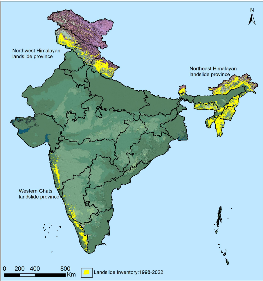
Image Source: NRSC (2023) Landslide Atlas of India.
The recently published Landslide Atlas of India by National Remote Sensing Centre, ISRO [4] provides an inventory of landslide-vulnerable regions of India in the Himalayas and Western Ghats. The database includes seasonal, event-based and route-wise landslide inventory over the time period of 2000-2017. The inventory database is available in a web GIS platform on the Bhuvan portal.
The landslide inventory database showing the hotspot areas and the landslide maps can be accessed here.
The atlas also provides information on the recent efforts being undertaken by the Department of Space to conduct landslide susceptibility zonation by taking into consideration the geological and topographical factors. This is to understand how and why the landslide has occurred and use this information to control factors triggering landslides and prevent damage caused due to the landslides in the future.
Which are the regions that are the most at risk due to landslides?
The Northwest Himalayas experience as high as 66.5 percent of landslides in India followed by Northeast Himalayas at 18.8 percent and the Western Ghats at 14.7 percent [4].
The Landslide Atlas of India by National Remote Sensing Centre, ISRO [4] provides information on landslide risk exposure by taking into consideration the socioeconomic parameters such as population, households, livestock and roads.
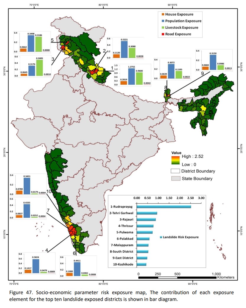
Image Source: NRSC (2023) Landslide Atlas of India.
The atlas provides a table that shows districts in India by their ranking according to their exposure to landslides by socioeconomic parameters. Rudraprayag and Tehri Garhwal districts in Uttarakhand top the list as the most at risk regions in the country.
The table can be viewed here
How many landslide events has India had in the recent past and where?
India witnessed a total 3,782 landslides between 2015 and 2022 with the highest of 2,239 being reported in Kerala followed by West Bengal (376), Tamil Nadu (196), Karnataka (194) and Jammu and Kashmir (184) [8].
Some of the worst landslides in India occurred in [9]:
- Northern Sikkim on September 24, 2012 when 27 people including members of the Indo-Tibetan Border Police (ITBP) died
- Dasalgaon in Maharashtra on July 27, 2007 which led to deaths of more than 50 people.
- Raigadh district in Maharashtra on July 26, 2005 when 54 people were killed due to landslides and floods.
- Sakinaka, Mumbai on July 26, 2005 where more than 74 people died
- Amboori in Kerala when 40 people were killed
- Malpa in Pithoragarh district of Uttarakhand in August 1998 where the landslide led to around 400 deaths
- Okhimath on August 14, 1998 – where 69 people died
- Konkan Coast on June 1994 when 20 people were killed
- Nagaland in August 1993 when 200 houses were destroyed, 500 people died and 5km stretch of a road was damaged
- Kalimpong, West Bengal in August 1993 when around 40 people were killed and property damaged.
- Itanagar in July 1993 where 25 people were buried alive.
- Assam in July 1991 when 300 people were killed and roads and buildings damaged [9].
The list of all socio economically significant landslides that happened between 2020 and 1948 in India can be accessed here
What are the consequences of landslides?
- Loss and threat to lives: This is one of the most devastating impacts of landslides on human survival and wellbeing. Landslides can lead to deaths and injuries from rapidly flowing water and debris and due to trauma or suffocation by entrapment.
- Damage to property and infrastructure: The fast flow of mud, debris, and rocks from a landslide can cause severe property damage. Infrastructure such as roads, railways, recreational destinations, buildings, water and sanitation systems, hospitals and health care systems, and communication systems are many a times destroyed by landslides creating further havoc [14].
- Economic losses: Large amount of resources are required to build back general and health care infrastructure due to the damage to property and resources and the negative impacts on human health and well being that a landslide can unleash.
- Health impacts such as injuries or illnessess: Destruction leading to lack of power, broken water supplies or gas and sewage pipes can lead to injuries, lead to water-borne diseases due to poor access to water supply and sanitation among populations and can also lead to short- and long-term mental health effects due to loss of family, property, livestock or crops.
- Damage to ecosystems: Materials that slide down along with landslides such as sediments, rocks, mud can enter rivers and other water bodies blocking their natural flow and impacting biodiversity and lives of humans depending on water bodies for water and livelihoods. [14, 15].
Measures required to prevent landslides
- Increasing forest cover on community lands, preventing destruction of trees
- Storing excess of water in catchment areas to reduce flashfloods and restore groundwater levels
- Limit grazing of animals and denuding landscapes
- Preventing destruction of ecosystems and preventing invasive activities such as drilling, construction etc leading to destruction of landscapes, hills, forests, water bodies etc due to urbanisation.
- Increasing public awareness and participation in spreading knowledge about landslides, their prevention and in recognising danger signals and dealing with emergencies in times of crisis [14].
What precautions should citizens take to prevent the risk of landslides?
The NDMA recommends certain precautionary measures to follow for landslides in the form of do's and dont's as given below:
Do's
- Plan your travel to hilly regions based on information given by weather department or news channels
- Move away from landslide paths or downstream valleys without wasting time in case of suspicion of a landslide
- Keep drains clean, and inspect them for litter, leaves, plastic bags, rubble etc.
- Keep the weep holes open
- Plant and grow more trees as they help in holding the soil through roots
- Find vulnerable areas of rock fall and subsidence, cracks, muddy river waters that indicate the risk of landslides or of landslides happening in the upper regions and move to safer areas.
- Contact the nearest Tehsil or District Head Quarters and inform them of the danger if you come across such signs to prevent loss of lives
- Ensure that toe of slope is not cut, remains protected, don't uproot trees unless re vegetation is planned
- Listen for unusual sounds such as trees cracking or boulders knocking together.
- Stay alert, awake and active (3A's) during the event of a landslide or indication of a landslide about to happen
- Try to stay with your family and friends
- Check for injured and trapped persons
- Mark your path so that you do not face the risk of getting lost following or during the landslide
- Learn how to give signals or how to communicate during emergencies to flying helicopters and rescue teams.
Dont's
- Try to avoid constructions and staying in vulnerable areas.
- Do not panic, keep your cool
- Do not touch or walk over loose material and electrical wiring or pole.
- Do not build houses near steep slopes and near drainage paths
- Do not drink contaminated water directly from rivers, springs, wells, but it is safe to drink directly collected rainwater in times of emergencies such as these [10].
Also view this link on the NDMA site to know more
What is being done at the policy level to reduce the risk of landslides in India?
Efforts are being undertaken by the National Disaster Management Authority (NDMA) to manage landslides and minimise their impacts in India.
In June 2009, the NDMA released the Guidelines on Management of Landslides and Snow Avalanches, thus laying down national policy for the management of landslides and related activities in the country. However, their implementation was limited in the landslide affected states/union territories.
In the guidelines, the following nine major areas have been identified for systematic and coordinated management of landslide hazards:
- Landslide hazard, vulnerability, and risk assessment
- Multi-hazard conceptualization
- Landslide remediation practice
- Research and development, monitoring and early warning
- Knowledge network and management
- Capacity building and training
- Public awareness and education
- Emergency preparedness and response
- Regulation and enforcement [12]
The complete document can be accessed here
On 19 December 2014, NDMA conducted a state-level meeting with landslide-prone states/UTs and concerned departments and institutes to discuss the ‘Landslide Risk Mitigation Scheme’ (LRMS) and other landslide-related issues. Representatives from fourteen states and nine departments participated in the meeting.
- Focus on landslide prone states and site specific risk mitigation
Based on this consultation, NDMA released a template for preparation of DPRs for site-specific landslide risk mitigation in June 2015 and circulated it to all the landslide affected states and union territories.
Landslide-risk mitigation was highlighted in the National Disaster Management Plan of 2016, which was updated in 2019. The importance of preparing their individual holistic disaster management plans was impressed upon all State/UT governments and other agencies.
n July 2019, NDMA launched the LRMS to provide financial and technical support to landslide-prone states for site-specific landslide mitigation [13].
Read more here
- Development of low-cost landslide monitoring and early warning system
In December 2017, NDMA launched a pilot project, ‘Development & Evaluation of Low-Cost Landslide Monitoring Solutions’, in collaboration with IIT Mandi and Defence Terrain Research Laboratory (DTRL)-DRDO. The project aimed to develop low-cost sensors and other instruments for landslide monitoring, using micro electro mechanical systems (MEMS)-based sensor technology and artificial intelligence. After detailed studies and experimentation, the project successfully developed a low-cost landslide monitoring, warning and prediction system.
- Innovations and Artificial Intelligence
Alerting mechanisms
The new system developed under this project presents advantages over the earlier technologies used and helps to detect whether there is significant soil movement and activates roadside blinkers and hooters wirelessly so that vehicular road traffic can be alerted. The blinkers and hooters come on for 10-15 seconds with lights and sound each time soil movement is recorded at the deployment site.
SMS to local people and disaster managers
In addition, the system also sends SMS messages about soil movements to disaster managers and the local people on their mobile phones. Recently, the system was been able to generate predictive messages about impending soil movements one day ahead of time as well as issue severe-weather advisories two hours ahead of severe weather events. The predictions of soil movements and severe weather are triggered by artificial intelligence (AI) algorithms running on a cloud-based server [13].
- Landslide Strategy
The recently published National Landslide Risk Management Strategy document addresses all the components of landslide disaster risk reduction and management, such as hazard mapping, monitoring and early warning systems, awareness programmes, capacity building and training, regulations and policies, stabilization and mitigation of landslides, etc
- Outcomes of NDMA Initiatives:
- Landslide Risk Mitigation Scheme (LRMS): The LRMS scheme will benefit landslide-prone states and union territories by helping them prevent future landslides by taking proactive initiatives through the lessons learnt under the scheme.
- Training programmes on Landslide Mitigation and DPR preparation: The training programme has been greatly beneficial to the landslide affected states/UTs, with the master trainers turned out by the programme assisting them in the preparation of DPRs for landslide treatment and in building the capacities of other stakeholders in their respective States/UTs.
- Development of low-cost landslide monitoring and EWS: Calibration and validation of data obtained at different landslides sites are in progress to generate a reliable early warning model to save precious lives. This low-cost landslide monitoring technology will be beneficial in saving lives and property in the future by providing early warning alerts to the community members and local administration [13].
For more details, please view the recently published National Landslide Risk Management Strategy document here.
/faqs/understanding-landslides