Term Path Alias
/topics/droughts-and-floods
/topics/droughts-and-floods

In the present study, two different Artificial Neural Networks (ANN) were developed for Dharoi reservoir, Gujarat, one for flood control operation and another for conservation operation. In recent years, ANNs are increasingly being used to predict water resources variables particularly in the operation of reservoirs, the most important elements of complex water resources systems, constructed for spatial and temporal distribution of water.
The report presents the effect of non hydrostatic pressure distribution on dam break flood wave movement. Dam break flood moves with non-hydrostatic pressure distribution in the vertical direction. However, almost all the mathematical models for dam break flows use Saint-Venant equation, which presume hydrostatic pressure in the vertical direction. In this report, an attempt has been made to use Boussinesq equations in the mathematical model.
Article Courtesy : Reuters AlertNet
Written by: Nita Bhalla
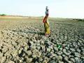
NEW DELHI (AlertNet) - Floods triggered by heavy monsoon rains have killed more than 50 people and displaced almost half a million more in India's south and northeast, say government officials.
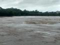
Overflowing rivers and reservoirs have inundated low-lying villages mainly in India's oil and tea-rich state of Assam, but also on the opposite side of country in the southwestern coastal state of Kerala.
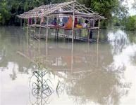
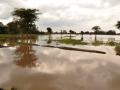
Flood-affected people sit in a damaged hut
as they wait for relief supplies in Lakhimpur
district, in India's northeastern state of Assam.
FILE PHOTO, July 2009. REUTERS/Stringer
According to the ministry of home affairs, almost one million people have been hit by the floods, forcing almost half a million to leave their water-logged villages and seek shelter in government relief camps.
Mountainous Assam, where five people have drowned, has been the worst-affected with 13 out of 27 districts hit by flooding, including Kokrajhar, Lakhimpur, Baksa and Bongaigaon.
In this study, Clark’s model has been used for derivation of one-hour unit hydrograph for a catchment. The design flood estimate has been obtained using the calibrated parameters of the Clark model together with the time-area diagram corresponding to a 48-hour design storm, which has been temporally distributed and critically sequenced as a single bell, giving due consideration to the ordinates of the unit hydrograph.
This report describes the study of regional flood frequency analysis using peak flood series data of gauging stations of Krishna basin based on at site and regional data combined using the following methods: (a) Index-Flood method (b) PWM based EVI distribution (c) PWM based GEV distribution and (d) PWM based Wakeby distribution.
The study attempts to do flood inundation and flood plain feature mapping as well as undertake river planform measurements for a part of the river reach of Satluj. The river is a part of the Indus system and faces flood during monsoon months in spite of various flood control measures that have been adopted. The vast expanse of land adjoining the river course is inundated by large floods.
The report deals with the hydrological aspects of flood disaster management, a multi-disciplinary field that endeavors to enhance the total productivity of the flood plains wherein losses are only a part of it. There are climatological and part-climatological causes of flooding and basin conditions, channel conditions and network conditions intensify floods.
The report presents regional flood frequency curves developed by fitting L-moment based GEV distribution to annual maximum peak flood data of small to medium sized catchments of the seven hydrometeorological sub-zones of zone 3 and combined zone 3 of India. The effect of regional heterogeneity is studied by comparing the growth factors of various sub-zones and combined zone 3. The flood frequency curves based on probability weighted moment (PWM) approach have been compared with the flood frequency curves based on L moment approach.
In the present study, design flood estimation of Morel catchment of Rajasthan state is computed using the Synder approach, regional relationships as proposed by Central Water Commission, Clark's model, Soil Conservation Services (SCS) method and Geomorphological Instantaneous Unit Hydrograph (GIUH) based approach.
The report presents an interactive software that has been developed to not only provide design flood estimates for large as well as small sized catchments but also help the users analyse their historical rainfall-runoff records for calibration and validation of the various techniques for part or whole of the catchment and river reaches.