Term Path Alias
/topics/droughts-and-floods
/topics/droughts-and-floods

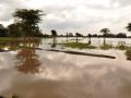
Arghyam has supported a Campaign for popularizing Rooftop Rainwater Harvesting (RWH) in a flood prone region in North Bihar. The second phase of the Abhiyan has been designed based on the experiences from the first phase.

Guest Post by: Deepak Bharti, SSVK
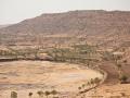
The following map from South Asia Network on Dams Rivers & People gives a schematic sketch of the Bagmati Breach site near Tajpur in Bihar’s Sitamarhi district.
Queries, request for information & additional clarifications can be sought via the comments section.
Download here: Rapid assessment report - Tilak Tajpur Panchayat
The google map at this URL shows Runi Sayedpur and Sitamarhi, along national highway 77: http://tinyurl.com/lxwfmj
1) A presentation from the Central Water Commission of the Government of India studying the flood problem on the Bagmati and making some recommendations:
flood-management-in-bagmati-basin
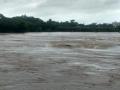
Photograph of flooding due to breach in Bagmati's embankment, taken by NGO: Ghoghardiha Prakhand Swarajya Vikas Sangh, Madhubani"
Guest Post by: Ranjan Panda
Sambalpur 27.5.2009
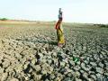
What 'Water Initiatives Orissa (WIO)' had found out three years ago have been substantiated now by a World Bank report, titled 'Climate Change Impacts in Drought and Flood Affected Areas: Case Studies in India'. The World Bank report , which took Orissa as a case study of flooding in a climate change scenarios - has referred to projections that 'temperatures, precipitation, and flooding are likely to increase, with adverse impacts on crop yields and farm incomes. Among the more substantial effects is a spatial shift in the pattern of rainfall towards the already flood-prone coastal areas'. Three years ago the WIO had found out significant increase in average annual rainfall in coastal districts like Baleswar and Puri. Now the World Bank report has projected 23 per cent increase in annual mean rainfall in that region.
These documents deal with proceedings of the discussion initiated by Gomukh Trust, Pune with support from Arghyam, Bangalore on “Maharashtra Water Resources Regulatory Authority Act” to examine it in the context of Integrated River Basin Management and community participation. The objectives of the conference were –
Flood warning: NASA (National Aeronautics and Space Administration, USA) has a realtime map that gives potential flood areas after 24 hours of rain. (The details of the criteria of flooding are not clear)