/sub-categories/maps
Maps
Map showing the site where river Bagmati breached its embankments in Sitamarhi, Bihar in 2009
Posted on 04 Aug, 2009 09:50 AMThe following map from South Asia Network on Dams Rivers & People gives a schematic sketch of the Bagmati Breach site near Tajpur in Bihar’s Sitamarhi district.
Background documents on the Bagmati embankment breach: Article and presentation
Posted on 03 Aug, 2009 09:46 AM1) A presentation from the Central Water Commission of the Government of India studying the flood problem on the Bagmati and making some recommendations:
flood-management-in-bagmati-basin
Real-time flood warning map from NASA
Posted on 01 Jun, 2009 05:29 PMFlood warning: NASA (National Aeronautics and Space Administration, USA) has a realtime map that gives potential flood areas after 24 hours of rain. (The details of the criteria of flooding are not clear)
Basin and water quality map for all major rivers of the country
Posted on 01 Jun, 2009 04:53 PMWatershed atlas of India from the Central Ground Water Board provides quite detailed basin maps for all major rivers of the country. To view the map by Central Ground Water Board click here
Integrated groundwater resources mapping in Gurgaon district, Haryana
Posted on 19 May, 2009 01:47 PMThis paper from the GIS Development site mainly deals with the preparation of integrated ground water resource (IGWR) map indicating ground water prospects, quality and depth.
Hydrogeology in watershed planning - a presentation by Advanced Center for Water Resources Development and Management
Posted on 18 May, 2009 01:17 PMThe presentation ends by making the following points:
Identification of suitable sites for water harvesting structures in Upper Betwa watershed through WARIS
Posted on 12 May, 2009 12:18 PMThis article by Rajashree V Bothale deals with the identification of suitable sites for water harvesting structures in Upper Betwa watershed through WARIS. The present study uses decision support system WARIS for identification of suitable sites for water harvesting structures.
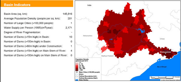
Basin maps of Mahanadi river showing basin indicators, landcover classes and biodiversity information and indicators
Posted on 17 Apr, 2009 02:07 PM
Basin indicators map of Mahanadi river basin
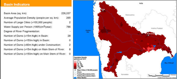
Basin maps of Krishna river showing basin indicators, landcover classes and biodiversity information and indicators
Posted on 17 Apr, 2009 01:25 PM
Basin indicators map of Krishna river basin
