Rajasthan Bagar

Term Path Alias

/regions/rajasthan-bagar

Water guards of Rajasthan
Taankas are trusted allies in the harsh weather of Rajasthan, but the focus is shifting now onto personal assets rather than community resources. Posted on 20 Sep, 2015 07:29 PM

We were driving down the long desert road that runs parallel to the Indo-Pakistan border in Jaisalmer, Rajasthan. There was little else to see except the surrounding sand dunes and desert grass.

A taanka in the Thar desert
Rajasthan's micro saviours need macro plans
North Rajasthan is making good use of subsidies for micro irrigation and solar water pumps but can this sustain? Posted on 28 Aug, 2015 09:49 PM

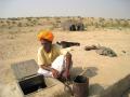
As we leave behind the smooth, straight drive of NH 89 and take a dirt path that whirls around a few miles of undulating desert grassland, we end at a large patch of emerald green which looks outlandish. “The reason for such a spectacle in these harsh conditions lies close to the ground,” says Ravinder Chhabra, my local guide in Bikaner.

Farmer Sunil Bishnoi has seen a five times rise in income from his farm thanks to drip irrigation.
Touched by very little water
Anupam Mishra talks about how the desert societies of Rajasthan have managed their scarce water resources for over 1000 years. Posted on 01 Aug, 2013 11:54 AM

Author and conservationist, Anupam Mishra has spent decades promoting water conservation and management. Through his travels across various states of India, he has been studying and teaching the time-tested techniques of rainwater harvesting.

Kunds and tankas have been used to collect water
कठपुतली बोलेगी कल की बात
बाड़मेर।भारतीय संस्कृति का प्रतिबिंब लोककलाओं में झलकता है। इन्हीं लोककलाओं में कठपुतली कला भी शामिल है। यह देश की सांस्कृतिक धरोहर होने के साथसाथ प्रचारप्रसार का सशक्त माध्यम भी है, लेकिन आधुनिक सभ्यता के चलते मनोरंजन के नित नए साधन आने से सदियों पुरानी यह कला अब लुप्त होने के कगार पर है। Posted on 09 Apr, 2012 03:10 PM

Puppets

Best meal of the day': Akshaya Patra's kitchen in Nathwara, Rajasthan is the newest of its high-technology ones across India
In a country of 1.2 billion people, fast moving towards economic superpower hood, it is a reality check, and a hard one too, that the mover and shaker of things here remains nothing but food. Indeed it is food alone that spawns a giant ripple effect – starting from the levels of education and health to eventually how development in the country finally shapes up. For, you cannot build a country on empty stomachs. Posted on 19 Mar, 2012 10:23 AM

Article and Image Courtesy : One World South Asia

Author : Madhusmita Hazarika

Rural water access: Governance and contestation in a semi-arid watershed in Udaipur, Rajasthan: A paper in EPW
Recent policy has encouraged a shift towards community management of water infrastructure through the creation of decentralised institutions.This also implies a shift from large to small structures and institutions. This however presumes the existence of a homogeneous 'community', and does not necessarily acknowledge the effect of various separate groups within such a community on these institutions. This paper published in Economic and Political Weekly (EPW) examines the impacts of this shift towards decentralised irrigation management on different groups residing in six villages in Rajasthan. Posted on 21 Feb, 2012 05:19 PM

Study area

This study is carried out in micro-watershed No.19, which comprises six villages in Jhadol tehsil of Udaipur district in Rajasthan. A minor irrigation project completed in 1980 serves these six villages

Rainfall, storage levels in reservoir and groundwater use

Impact of climate change in India: An agro - ecological zone level analysis
A detailed look at the possible impacts of climate change on the different agro - ecological zones demarcated in India Posted on 20 Aug, 2009 06:04 PM

India is gifted with heterogeneous landforms and variety of climatic conditions such as the lofty mountains, the raverine deltas, high altitude forests, peninsular plateaus, variety of geological formations endowed with temperature varying from arctic cold to equatorial hot, and rainfall from extreme aridity with a few cms (<10 cm) to pre humid with world's maxim

India - Physical Map from the Survey of India (2002)
A definitive physical features map of the country from the Survey of India, showing elevation in metres of different regions and major rivers and land formations. Posted on 18 Aug, 2009 05:35 PM

Download the map from the attachment listed below:

×