Political

Term Path Alias

/regions/political

Mapping the soils of India: Survey of India
A detailed map on the different soil types in India from the premier mapping organization of the country, Survey of India Posted on 20 Aug, 2009 04:11 PM

Soils constitute the upper portion of the earth's crust, and are the base of human habiation on the earth. India has a great variety of soils, with over 29 major types.

The map can be accessed from the Survey of India website

Download the map from the link provided below:

Fed by rain - India's rainfed and poorest areas overlap
India's rainfed areas are agriculture intensive - 85% of the employed people in these areas are engaged in agriculture. Posted on 20 Aug, 2009 03:52 PM

Consisting mainly of arid and semi-arid areas and the country's 200 backward districts, these rainfed regions are concentrated in 13 states.

Technologies for lake restoration: A paper from Helmut Klapper on water quality and restoration of lakes
A paper on economical and ecologically safe technologies that will greatly enable restoration of lakes Posted on 20 Aug, 2009 03:46 PM

Download this guide to technologies which can assist you in your goal to restore lakes.

Read more on the Journal of Limnology

Ramsar convention policies: Concept and mission
The Ramsar Convention Policies are acknowledged worldwide as an authority on the protection of wetlands. Posted on 20 Aug, 2009 03:31 PM

The Ramsar Convention’s ‘wise use’ concept defined as ‘the maintenance of the wetlands ecological character, achieved through the implementation of ecosystem approaches, within the context of sustainable development’, has guided various measures for the sustainable use of wetlands and their resources, for the benefit of humankind.

Revival of ancient water tanks in India: Case studies from Karnataka and Tamilnadu
This page will help you learn more about how the revival of ancient water tanks is once again benefiting the community today Posted on 20 Aug, 2009 03:26 PM

Centuries old dried up water tanks have been revived with the combined efforts of the local community and the authorities.

Map: Location of water resource projects across river basins in India
This map from the National Institute of Hydrology shows the location of the various water resources projects in each river basin in the country. Posted on 20 Aug, 2009 03:23 PM

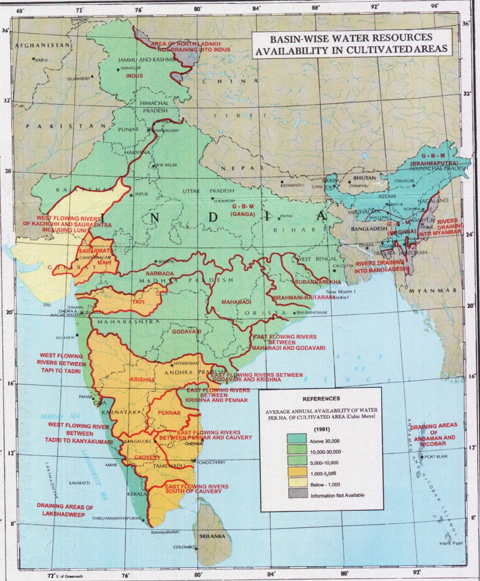
The map indicates that across the main 19 river basins of the country, water resource projects with a total live storage of 174 BCM (Billion Cubic Metres) have been completed, 75 BCM are ongoing, and 132 BCM are being planned.

Annual average availability of water for agriculture in India as of 1991
This map shows the river basin-wise annual average availability of water (in m3) for agricultural cultivation, as of 1991 Posted on 20 Aug, 2009 02:50 PM

/sites/default/files/iwp/Basin-wise%20annual%20average%20availability%20of%20water%20for%20agriculture_1991_NIH.jpg

Save the lakes campaign - Restore Hyderabad's Hussain Sagar
The ‘Save the Lakes’ Campaign was started by a number of concerned citizens in Hyderabad in order to restore the Hussain Sagar Lake. Posted on 20 Aug, 2009 02:48 PM

Read the report for a comprehensive background on the campaign, along with the techniques used, chronology and dateline as well as the important people to contact.

This link was sourced from the website of Centre of Science and Environment

Rashtrita Jal Chetna Yatra: Efforts of Tarun Bharat Sangh and Rajendar Singh in addressing water related concerns across the country
A detailed write up about the aims, aspirations and achievements of the Rashtriya Jal Chetna Yatra Posted on 20 Aug, 2009 02:20 PM

Tarun Bharat Sangh and Rajendar Singh started a massive campaign to spread awareness of traditional water harvesting structures in order to restore the water resources of arid Rajasthan. The aim was to popularize the use of such traditional structures across the country.

Map: Average annual temperature in India
This thematic map from Wikimedia Commons provides information about the average annual temperature in India Posted on 20 Aug, 2009 02:15 PM

This map from Wikimedia provides information on the average annual temperature figures across the country over a range of below 20 Deg C and above 27.5 Deg C.

×