/regions/political
Political
Conducted open source GIS training for United Nations Population Fund
Posted on 08 Nov, 2010 08:37 PMTwo Weeks Customized training program on Quantum GIS and GRASS GIS for Census Department was conducted by United Nations Population Fund Office(UNFPA), Koreain Collaboration with Magendhiran Consultancy Services from 18th - 29th Oct 2010.
Call for papers for national workshop on "Impacts of Watershed on Poverty Alleviation", CWLR, Hyderabad
Posted on 08 Nov, 2010 11:54 AMOrganizer: Centre for Water and Land Resources (CWLR)
Venue: National Institute of Rural Development (NIRD)
Description:
This workshop is aimed at to explore the linkages between watershed development and poverty. Watershed is one of the strong interventions for reharnessing the natural resources which benefits the rural poor. Many projects of watershed are implemented by the different agencies. The impact on poverty is one of the issues in watershed programme which needs to be unraveled for further policy options.
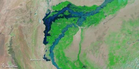
Flooding in Pakistan: Updates from Earth Observatory
Posted on 08 Nov, 2010 10:54 AMFlooding in Pakistan

Open courseware of national programme on technology enhanced learning A summary of civil engineering courses
Posted on 06 Nov, 2010 07:59 AMThe India Water Portal is pleased to announce to its users, that the Civil Engineering courses from the multi-faceted and multi-modal open courseware of National Programme on Technology Enhanced Learning (NPTEL) have been put together in the form of a summary. These courses are being carried out by Indian Institutes of Technology and the Indian Institute of Science Bangalore as a collaborative project supported by the Ministry of Human Resource Development (Government of India) to enhance the quality of engineering education in the country, by developing curriculum based video and web courses. In these web based lectures, the authors have developed the subject in detail and in stages in a student-friendly manner.
A case study of Dongs – The traditional water management system of the Bodo people
Posted on 05 Nov, 2010 05:24 PMThis report by SDTT presents a case study on the traditional water management system of the bodo people in Assam and North Bengal, the dongs. Dongs are man-made structures akin to canals, to route water from available water sources, which are usually perennial, to the paddy cultivating fields. The water sources are small rivers, perennial swamps, beel, streams, etc. Dong can have a breadth of 7-15 feet on average or even more. The breadth gradually increases over the course of its flow from the source till the end point.
A training manual on integrated management of watersheds by ICRISAT
Posted on 05 Nov, 2010 12:05 PMThe training manual by ICRISAT on integrated management of watersheds is meant for watershed development practitioners and provides an account of the socio-technical aspects of watershed. To begin with, the definitional aspects of watershed are spelt out -
- The term “watershed” strictly refers to the divide separating one drainage basin from another. However, over the years, the use of the term watershed to signify a drainage basin or catchment area has come to stay.
- Hydrologically, watershed could be defined as an area from which the runoff drains through a particular point in the drainage system.
Gully control in semi arid tropical watersheds – A report by ICRISAT
Posted on 04 Nov, 2010 09:21 PMThis report prepared by ICRISAT under its Global Theme on Agroecosystems deals with the problem of gully erosion, which is common in the semi-arid region, characterized by denuded landscape and flash floods. An estimated 4 million ha land in India and 29 million ha of land in Africa are affected by severe gully erosion. Gully erosion is more difficult and expensive to control than other types of soil erosion.
Training program on analysis and design of dams, NWA, Pune
Posted on 04 Nov, 2010 05:20 PMOrganizer: National Water Academy (NWA)
Training program on preparation of detailed project report, NWA, Pune
Posted on 04 Nov, 2010 04:39 PMOrganizer: National Water Academy (NWA)
Call for Papers: 35th Water, Engineering and Development Centre (WEDC) International Conference
Posted on 04 Nov, 2010 10:46 AMContent and Image Courtesy: Water, Engineering and Development Centre (WEDC)
The future of water, sanitation and hygiene in low-income countries: Innovation, adaptation and engagement in a changing world.