/sub-categories/news-and-articles
News and Articles
Providing a plan to save civilization - Books from the Earth Policy Institute
Posted on 11 Jul, 2010 05:24 AM Earth Policy Institute, is a non-profit environmental research organization dedicated to providing a vision of an eco-economy and a roadmap on how to get there. The Institute was founded in 2001 with the following goals:
- to provide a global plan (Plan B) for moving the world onto an environmentally and economically sustainable path
- to provide examples demonstrating how the plan would work, and
- to keep the media, policymakers, academics, environmentalists, and other decision-makers focused on the process of building a Plan B economy.
The basic research of the Institute has been published in the form of seven books:
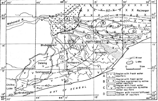
A study of saline freshwater interface phenomena in the Mahanadi delta region (Orissa)
Posted on 10 Jul, 2010 10:40 PM The subsurface aquifer systems in Mahanadi delta region in Orissa (India) is largely characterized by two groups of freshwater aquifer systems, both of which are prone to saline water mixing/migration with time and development:
- The south western Mahanadi delta region is represented by unconfined to semi-confined freshwater aquifers underlained by brackish/saline aquifer systems with a diffusion boundary.
- The north eastern parts of Mahanadi delta is represented by deep freshwater confined aquifers overlained by brackish/saline water aquifers with aquitard/ aquiclude boundary.
Development of instrument for automation of irrigation scheduling and groundwater recharge monitoring using soil moisture measurement – A research report by National Institute of Hydrology
Posted on 10 Jul, 2010 06:35 PMThe report presents development of a sensor system capable of automated measurement of soil-water status, using the four-electrode resistivity (VES) method, in a soil profile. In this method, by changing the separation between two electrodes (metallic rods) placed at the ground surface without digging any holes, the variation in moisture content in the sub-surface soil profile can be monitored.
Development of relationship between glacier melt runoff and meteorological parameters – A research report by National Institute of Hydrology
Posted on 10 Jul, 2010 04:35 PMThe study attempts to develop a relationship between glacier melt runoff and meteorological parameters for the Dokriani glacier in Garhwal Himalayas. The discharge auto-correlation, correlation between discharge & temperature and between discharge & rainfall has been computed for each month of the summer season and for the melt season as a whole for different years.
A baseline survey of groundwater quality in coastal aquifers of Andhra Pradesh - A research report by National Institute of Hydrology
Posted on 10 Jul, 2010 01:09 PMThe study provides an analysis of groundwater quality to identify probable pollution or contamination in coastal aquifers of Kakinada in Andhra Pradesh. Sampling surveys have been conducted in the months of May 99, August 99 and November 99 and about 186 water samples were collected from shallow wells, filter points, canal water and rainwater. The spatial and temporal variations of water quality parameters are presented in the report.
Reservoir sedimentation study for Ukai dam using satellite data - A research report by National Institute of Hydrology
Posted on 10 Jul, 2010 11:39 AMThe report presents a sedimentation study in which sedimentation rate and volume have been determined using remote sensing data in the Ukai reservoir constructed across the Tapti River in Gujarat.
Software for a hydrological data year book – A report by National Institute of Hydrology
Posted on 10 Jul, 2010 10:39 AMThe report deals with software developed by the National Institute of Hydrology with the purpose of preparation of hydrological data book in a form most valuable to the users. A menu driven, user friendly software has been developed to handle all types of hydrological and meteorological data.
Still reporting rainfall in inches and dam gauges in feet
Posted on 09 Jul, 2010 12:18 PMWe have adopted the metric system long back (1957) and there was a grace period of 10 years for transition from British units to metric units.
Systematic procedure for the computation of evaporation from lakes - A research report by National Institute of Hydrology
Posted on 08 Jul, 2010 10:49 PMThe report presents a systematic procedure for the computation of evaporation from lakes. Water balance of a lake depends upon the relative importance of various inputs and outputs to and from the lake. In Indian conditions, evaporation loss constitutes one of the major outputs from a lake and as such, the water regime of a lake and yield are influenced by it. In order to conserve and use the water, there is an urgent need for a first hand reasonable accurate estimate of its water balance.
Water quality studies of Lake Nainital and surroundings – A research report by National Institute of Hydrology
Posted on 08 Jul, 2010 09:57 PMThe report provides an account of the findings of water quality studies of Lake Nainital and surroundings. Even though quite a few water quality investigations have been conducted by other researchers, they were more focused on biological aspects and overlooked the hydrological aspects. Further, not all of the earlier studies on Nainital incorporated the groundwater quality aspects, which are essential to establish the background values that can be ascribed to the geology of the region. Only after establishing these, the pollution levels can be assessed.