/sub-categories/events
Events
Geomatrix '12, IITB, February 26-29, 2012, Mumbai
Posted on 19 Jan, 2012 10:05 AMOrganizer: Indian Institute of Technology Bombay (IITB).
Venue: Indian Institute of Technology Bombay (IITB), Powai, Mumbai - 400076

Description:
Geomatrix’12 is the third in a series of conferences on geoinformatics tools, techniques and applications being organized by the Centre of Studies in Resources Engineering (CSRE), IITB since 2009. The first two conferences were national level conferences; Geomatrix’12 is envisaged to be an international event with strong participation from national and international researchers and institutes of repute at both organization and delegate level.
National seminar on geospatial technology development in natural resource and disaster management, MSU, February 23-24, 2012, Tirunelveli, Tamil Nadu
Posted on 19 Jan, 2012 09:35 AMOrganizer: Manonmaniam Sundaranar University (MSU)
Venue: Tirunelveli, Tamil Nadu - India
India Geospatial Forum 2012, GMC, February 8-9, 2012, Gurgaon
Posted on 18 Jan, 2012 07:53 PMOrganizer: Geospatial Media & Communication.
Venue: Epicentre, Apparel House, Gurgaon, Harayana.

Description:
As one of the most important Indian Geospatial Industry Event, India Geospatial Forum 2012 will bring the stakeholders —solution / service providers, policy makers, users — to a single platform, providing supreme opportunities for discussion, deliberation and interaction.
Bhoomi conference 'Campaign for a Million Eco Projects', January 21 & 22, 2012, Bangalore
Posted on 17 Jan, 2012 04:24 PMOrganizers: Bhoomi Network for Sustainable Living

Description:
Bhoomi Network are happy to invite you for our Bhoomi Unconference on a theme that we can all focus on for a long long time - Campaign for a Million Eco Projects.
One World – A collection of stunning images by Dr. Anish Andheria, Sanctuary, January 15 to 21, 2012, Mumbai
Posted on 16 Jan, 2012 10:49 AMSanctuary Magazine, aims to communicate the rationale for wildlife conservation and environmental protection. Their focus is the Indian subcontinent and Asia, but their horizon spans the globe.
Organizer: Sanctuary Magazine
A water works science fair for children, Hippocampus and Curiouscity, Bangalore, January 18-22, 2012
Posted on 12 Jan, 2012 10:59 AMOrganizer: Hippocampus,
Curiouscity.
One day seminar ‘What we must do to save the rivers of Maharashtra’, NWO, Pune, January 30, 2012
Posted on 12 Jan, 2012 10:21 AMOrganizers: National Womens Organization (NWO),
Gandhi National Memorial Society(GNMS),
National Ganga River Basin Authority (NGRBA).
Living rivers, dying rivers: Bagmati river in Nepal
Posted on 05 Jan, 2012 06:07 PMBagmati river in Kathmandu: From holy river to unthinkable flowing filth

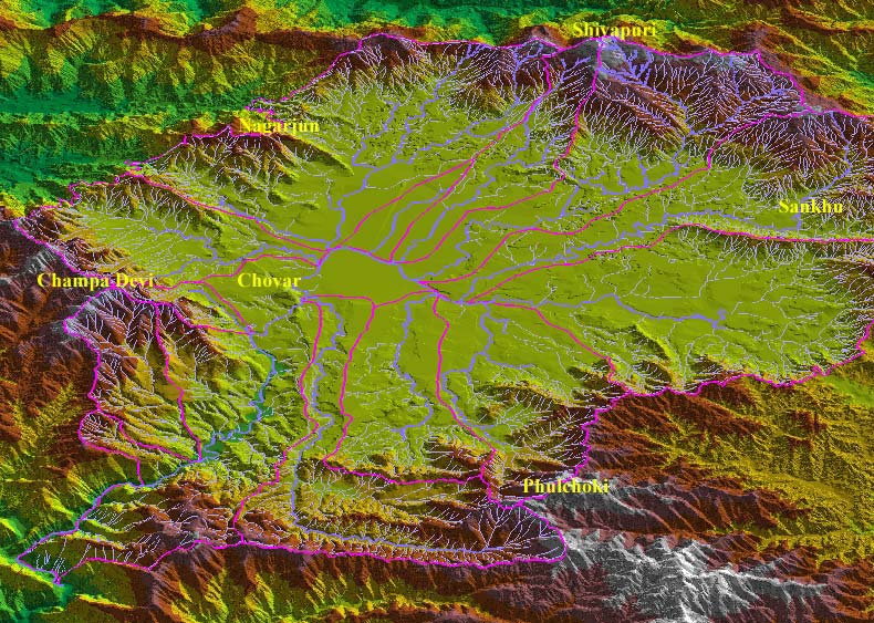
Ajaya Dixit initiated his presentation with a general account of how rivers shape the landscape and how riverine ecosystems have nurtured society and kept civilisations vibrant, cultured and creative. Dixit went on to discuss the basin characteristics of the Bagmati, a tributary of the Kosi that rises in the Shivapuri hills, north of the Kathmandu valley. Around fifteen percent of the basin area (3700 sqkm) lies in Nepal, while the remaining is in India. The average annual rainfall in the basin is 1400 mm and is more than 2000 mm in the hills. Bagmati is a seasonal river with rainfall and springs as its main source. Its mean flow is 15.6 cubic metre/second and low flow is 0.15 cubic metre/second in April.
Kathmandu lies in the Upper Bagmati basin and studies suggest that an ancient lake called the Paleo-Kathmandu lay within the Kathmandu valley as a lacustrine formation. Early settlers lived in lower slopes and used springs and river in the upper reaches. When they moved to the valley floor, they built dongia dharas, which are stone water spouts fed by the unconfined aquifers and delivered water through surface channels. Even today, dongia dharas dated back to 1500 years exist. The state built canals (raj kulo) tapped the upper stretches of the rivers close to the mountains. Rivers and irrigation helped recharge aquifers and ponds.
However, rising urbanisation has damaged these ancient artifacts. Over the last sixty years Kathmandu has expanded massively and its population has increased from 0.41 million in 1951 to 2.6 million in 2011. The city has a huge transient population aside from this, reducing it to a concrete nightmare. Seismologists suggest that Kathmandu is a rubble city in the making. Though the Bagmati river flow has not changed significantly in the last seventy years, the character of the river has been transformed significantly during the period 1970 to 1990. The river has been canalised while the dumping of the city’s garbage into it continues. Dixit identified a plethora of problems faced by the river such as upstream water diversion for drinking water needs, disposal of untreated liquid waste, disposal of solid waste, river jacketing for roads and commercial activities, sand mining and physical encroachment.
The state of the river is an outcome of the current approach to waste management particularly liquid waste management. Three types of waste water namely yellow water flux, grey water and yellow black flux are being generated and flowing water is being used as a vehicle to dispose these. The idea of a water based disposal system e.g. flush toilet embedded in Victorian engineering has led to a technological lock-in with the result that the notion of a natural hydrological cycle has undergone a fundamental transformation.
All the same, the bulk of the load in the river is biological though there are some factories releasing effluents. In the last 20 years some of them have been closed or relocated and the river now stands a chance of being salvaged.

Second WMO international conference on "Indian Ocean Tropical Cyclones and Climate Change", IMD, February 14-17, 2012, New Delhi
Posted on 05 Jan, 2012 08:04 AM

