Advanced Centre for Water Resources Development and Management (ACWADAM)
Earth sciences in watershed management – A presentation by ACWADAM
Posted on 23 Sep, 2010 08:04 AMThis presentation by ACWADAM on earth sciences in watershed management shows how the occurrence of water within a watershed is governed by the rock types occurring both at the surface and within the subsurface, their sequence and their structure. The presentation deals with the basic components involved in the mapping of a watershed –
- The type of rocks (lithology), and
- The structure (whether these are folded, faulted, fractured, jointed etc.,)
The structure of the sub-surface – A presentation by ACWADAM
Posted on 22 Sep, 2010 09:38 PMThis presentation by ACWADAM deals with the structure of the sub-surface. The lithology and structure of rocks together define the geometric framework for the movement of groundwater. To some extent, these factors also govern the movement of surface water too. In other words, the physical environment of rocks and rock material hosts water, and hence, controls its accumulation and flow in the watershed.
Importance of groundwater – A presentation by ACWADAM
Posted on 22 Sep, 2010 08:03 PMThis presentation by ACWADAM deals with the importance of groundwater. It is well-known fact that groundwater forms a very crucial source of water supply in the national scenario on water resources today. And yet, it continues to remain a resource that is both abused and misused. Often, watershed projects suffer from insufficient inputs, especially hydrogeological to address the problem(s) of groundwater within the watersheds.

India’s groundwater typologies – A presentation by ACWADAM
Posted on 22 Sep, 2010 08:01 AMThis presentation by ACWADAM deals with groundwater typologies in India. The typology of groundwater can be defined in many ways based on a) Uses of Groundwater, b) Geography, c) Geology, d) Hydrogeology (Aquifers), e) Groundwater Quality, f) Stage of Groundwater Development, and g) Socio-ecology of Groundwater.
Integrated Data Management Systems using Geographic Information Systems – A presentation by ACWADAM
Posted on 21 Sep, 2010 11:25 PMThis presentation by ACWADAM deals with integrated data management using Geographic Information Systems. A Geographic Information System (GIS) integrates hardware, software, and data for capturing, managing, analyzing, and displaying all forms of geographically referenced information.
Chemistry of groundwater – A presentation by ACWADAM
Posted on 21 Sep, 2010 10:40 PMThis presentation by ACWADAM deals with the chemistry of groundwater. It is now recognized that the quality of groundwater is as important as its quantity. All groundwater contains salts in solution which are derived from the location and the movement of water through rocks. The quality of groundwater supply depends where and for what it is planned to be used. Thus water quality standards for drinking water, industrial water and irrigation water differ significantly.
Groundwater balance – A presentation by ACWADAM
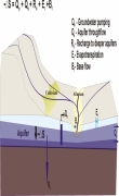
Posted on 21 Sep, 2010 10:00 PM This presentation by ACWADAM deals with the subject of groundwater balance. It begins by describing the skeleton for the water balance equation viz., ground surface, soil, aquifer and bed rock. It describes the processes subsequent to rainfall such as interception, initial detention, depression storage, infiltration, runoff, streamflow, soil moisture retention and recharge.
The watershed water balance equation is explained in terms of input (rainfall and water transfers) and output (runoff, evapotranspiration and infiltration). It notes that the input to a generalized water balance is rainfall whereas the input to a groundwater balance is infiltration. The difference between infiltration & recharge, natural & artificial recharge and interflow & discharge are explained thereafter. The water balance for an aquifer may vary, depending upon the nature of groundwater system –
- Watershed with a deep aquifer
- Watershed has both shallow and deep aquifers
- Watershed has only shallow aquifer
Geological mapping – A presentation by ACWADAM
Posted on 21 Sep, 2010 08:27 AMThis presentation by ACWADAM deals with geological mapping. The occurrence of water within a watershed is governed by the rock types occurring both at the surface and within the subsurface, their sequence and their structure. The physical structure which plays host to the water within the watershed is geological. Every watershed programme must therefore include a fundamental understanding of this framework so that the development and management measures planned through such programmes are meaningful and properly justified technically.
Remote sensing – A presentation by ACWADAM
Posted on 21 Sep, 2010 07:24 AMThese presentations by ACWADAM deal with the application of remote sensing and aerial photography techniques in groundwater management. Remote sensing is a technique by virtue of which information about an object, area or phenomenon is obtained with the help of a sensor on board a platform from distance without coming in contact with object, area or phenomenon.
Groundwater management: Conceptual framework – A presentation by ACWADAM
Posted on 20 Sep, 2010 08:36 PMThis presentation by ACWADAM deals with the conceptual framework of groundwater management.